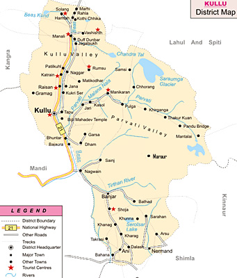
 Kullu District is one of the 12 administrative districts of Himachal Pradesh with its headquarters at Kullu town. District headquarter is situated at an altitude of 1200 metres. Average altitude of Kullu District is 1219 metres above the sea level. With a total area of 5503 square kilometre, Kullu was recognised as a district in the year 1963.
Location of Kullu District
Kullu District is located at 31 degree 20 minutes 25 seconds to 32 degree 25 minutes north latitude and 76 degree 56 minutes 30 seconds to 77 degree 52 minutes and 20 seconds east longitude. This district of Himachal Pradesh is bounded on the north and east by Lahaul and Spiti District. On the south-east, it is bounded by Kinnaur District. Kullu District is bounded by Shimla district on the south. Further, on the south-west and west it is bounded by Mandi district and, on the north-west by Kangra District.
History of Kullu District
There are several references of Kullu in Ramayana and Mahabharata, Vishnu Purana and other Sanskrit literature. Kullu was probably the most ancient state next to Kashmir and Kangra. Like other hill states, Kullu had its ups and downs till it was ceded to the British government in 1846 according to Lahore agreement, along with other trans-Sutlej states. Kullu was made a sub-division of Kangra District. Lahul-Spiti was attached to Kullu for administration. In 1960 Lahul-Spiti was made a separate district. Kullu was also declared a district in 1963 and was a part of Punjab up to October 1966. On 1st November 1966, after the reorganisation of states, Kullu became a separate district of Himachal Pradesh.
Geography of Kullu District
Generally, the climate of Kullu District is cold and dry and the year can be divided into three seasons mainly summer season from March to June, rainy season from July to September and winter season from October to February. From December to February, this period is very chilly. Heavy frost occurs during this period. Snowfall generally occurs during December and January or an early snowfall may occur in November also. During this period, most of the parts of Kullu remain under cover of snow. The average rain fall is 80 cm. Maximum mean temperature recorded in this district is around 38 degree Celsius and minimum temperature is around 5 degree Celsius in winter.
Demography of Kullu District
According to 2001 census, Kullu district has a total population of 3, 81,571. The rural population is estimated to be 3, 51,478. On the other hand, the urban population is 30,093. Further, the literacy rate of Kullu District is 72.90 percent. There are a number of primary, middle and high schools scattered throughout the district. The district has around two colleges. The male literacy rate in the district is around 83.98 percent while the female literacy rate is 60.88 percent.
Tourism in Kullu District
Kullu District is known for its temples, ancient sites, waterfalls and amazing scenic beauty. It offers plenty of exploring opportunities. Some of the main attractions offered by Kullu District include Kullu, Manali, Naggar, Rohtang Pass, Nehru Kund, Arjun Gufa, Solang Valley, Dhar Deo Dhank Cave, Raghunath Temple, Bijli Mahadev Temple, Vaishno Devi Temple, Bishweshwer Temple, Addi Brahma Temple, Rama Temple, Manu Maharaj Temple, Sandhya Devi Temple, Vashishta Rishi Temple, Dashal Temple, Tripura Sundari Temple, Ambika Temple and more.
Kullu is located at a distance of 70 kms from Mandi and 312 km from Chandigarh.


