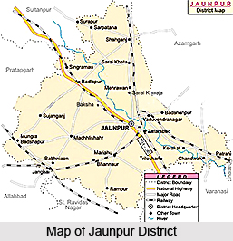
 Jaunpur District is situated in the north-west part of Varanasi Division of Uttar Pradesh. This district extends from 24.24 degree north to 26.12 degree north latitude and between 82.7 degree east and 83.5 degree east longitude. Average altitude of Jaunpur District varies from 261 feet to 290 feet above the mean sea level. The geographical area of Jaunpur District is 4038 sq kms. According to 2001 census, total population of Jaunpur District is 39,11,305, in which female population is 19,75,729 and male population is 19,35,516. Jaunpur town is the district headquarters.
History of Jaunpur District
Jaunpur was established by Firoz Shah Tughlaq. The name of Jaunpur was derived from the name of Sultan Muhammad. About 1394 AD Malik Sarvar established the Sarki Empire. During his reign several mosques and other monuments were built in this district. In around 1730 AD Sarki Empire moved to Southern Sindh, which is now in Pakistan.
Geography of Jaunpur District
Topography of Jaunpur District mainly includes flat plain with shallow river-valleys. Gomti River and Sai River are the main rivers flowing through the district. Soils of the district are mainly sandy, loamy and clayey. There is a scarcity of minerals in Jaunpur District. The temperatures of this district lie between a minimum of around 4 degree Celsius and a maximum of near about 44 degree Celsius. Average annual rainfall in Jaunpur District is 987 mm.
Economy of Jaunpur District
The economic development of Jaunpur District is mainly dependent on agriculture. Three fourths of the population of the district of Jaunpur is dependent on agriculture. The chief cause of this is the absence of heavy industries. However, several industries are coming up along Varanasi Jaunpur highway. A cotton mill is operational near Karanja Kala. Animal husbandry also constitutes a sector of economy of Jaunpur District.
Administration of Jaunpur District
From the administrative point of view, Jaunpur District has been divided into six tehsils in order to maintain law and order and for proper implementation of the developmental works. The six sub-divisions of this district are Sadar, Madiyahun, Machhalishahar, Kerakat, Shahganj and Badlapur. Further, administrative set-up of Jaunpur District has been divided into 21 Development Blocks - Sondhi (Shahganj), Suithakala, Khutahan, Karanja Kala, Badlapur, Maharajganj, Sujanganj, Baksha, Mungrabadshahpur, Machhalishahar, Madiyahun, Barsathi, Rampur, Ramnagar, Jalalpur, Kerakat, Dobhi, Muftiganj, Dharmapur, Sikrara and Sirkoni. Jaunpur District has been divided into 27 police stations - Kotwali, Sadar, Line Bazar, Jafrabad, Khetasarai, Shahganj, Sarpatahan, Kerakat, Chandwak, Jalalpur, Sarai Khwaja, Gaurabadshahpur, Badlapur, Khutahan, Singramau, Baksha, Sujanganj, Maharajganj, Mungrabadshahpur, Pawara, Machhalishahar, Mirganj, Sikrara, Madiyahun, Rampur, Barsathi, Nevadhiya and Sureri. District Magistrate is the head of administration of Jaunpur District.
Jaunpur District is known for its various historical monuments, which are worth exploring.


