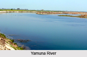
 Geography of Sonipat District does not include any perennial river. The underground water resources differ from one area to another. The depth of the water table is lowest in Khader area along Yamuna River, where it is below 10 feet. Ground water in some areas of the district is saline and brackish. The ground water conditions indicate that the district faces the problem of occurrence of brackish water and water logging in eastern parts of the district. Sonipat District is a continuous part of the Haryana-Punjab plain, but the area is not levelled in some parts. Sonipat District has fine loamy soil with rich color. However, some areas have sandy soil.
Sonipat District may be topographically divided into three regions - Khadar, Upland Plain and Sandy Region. Khadar region along River Yamuna is a narrow flood plain, 3 to 6 km wide, and is formed by the river along its course. Khadar plain is 20 to 30 feet lower adjoining the upland plain. Presently, rice and sugarcane cultivation is undertaken in the Khadar area. Upland plains of the district consist of Sonipat tehsil lying to the west of Khadar, and are the most extensive of the three regions. The upland plain is covered with old alluvium, which if properly irrigated, is highly productive. Extensive farming of crops, oilseeds, horticultural plants, vegetables and flowers, is undertaken in this region. Sandy region constitutes a very small part of the district. This region mainly covered with sandy soils.
 Climate of Sonipat District is dry with hot summer and a cold winter. The weather becomes milder during the monsoon period from July to September. The post-monsoon months October and November constitute a transition period, prior to the onset of winter. Winter starts in December when day and night temperatures fall rapidly. January is the coldest month when the mean daily minimum temperature is 6 degree to 7 degree Celsius. During the summer months of May and June, the maximum temperature sometimes reaches 47 degree Celsius. Temperature drops considerably with the advancement of monsoon in June. Humidity is considerably low during the greater part of the year. The district experiences high humidity only during the monsoon period. The period of minimum humidity less than 20 percent is between April and May.
The annual rainfall of Sonipat District varies considerably from year to year. However, the maximum rainfall is experienced during the monsoon season, which reaches its peak in the month of July. In fact, the monsoon period accounts for 75 percent of the annual rainfall in the district. On an average there are 24 days in a year with rainfall of 2.5 mm or more per day in Sonipat District. During the monsoon season, the sky is heavily clouded, and winds are strong in this period. Winds are generally light during the post-monsoon and winter months. Further, geography of Sonipat District also consists of specific weather phenomena. Sonipat District experiences a high incidence of thunder storms and dust storms, often accompanied by violent squalls during the period April to June. Sometimes the thunder storms are being accompanied by heavy rain and occasionally by hail storms. In the winter months, fogs sometimes appear in the district.


