 On 1st January, 1997 the Tiruvallur District was the newly developed district formed by the bifurcation of the erstwhile Chengalpattu district. Located in the north eastern part of the state of Tamil Nadu, the Tiruvallur District was originally known as Tiruvallur which specifies the sleeping position of holy Lord Balaji. Afterwards, people began to refer Tiruvallur by names like Trivellore and Tiruvallur. The Tiruvallur District is well known today for the Veeraragava Temple.
History of Tiruvallur District
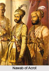
An insight into the early history of the Tiruvallur District shows that the region was under a chain of different regimes commencing from the Pallavas during the 7th century ending with the Nawabs of Arcot during the early 19th century until it came under the British rule. In 1687, the Golkonda rulers were defeated and the region came under the Mughal emperors of Delhi. The villages and towns of the Tiruvallur District were the scene of Carnatic war. Battles are said to have been fought in this region during the struggle for supremacy between the French and the English. Founded in 1609, the town of Pulicat was the earliest Dutch possession in India which was ceded to the British in the year 1825. With this, the region came under the British rule which ended on the 15th August, 1947 with India becoming independent.
 Geography of Tiruvallur District
The Tiruvallur District is located in the north-eastern parts of the state of Tamil Nadu. It is situated between 12 degree 15 minutes and 13 degree 15 minutes to the north latitude and between 79 degree 15 minutes and 80 degree 20 minutes to the east longitude. The Tiruvallur District is surrounded by the Kanchipuram district to the South, Vellore district to the West, the Bay of Bengal to the East and the state of Andhra Pradesh to the North. The district of Tiruvallur is spread over an area of about 3422 sq. km. The district`s coastal region is mostly flat and dreary while in the other parts it is undulating and even hilly in some places.
The northern taluks like Ponneri, Uttukkottai, Gummidipundi, etc. do not have much to offer from the scenic point of view. In the Tiruttani taluk, a number of hillocks are found scattered. Here soil is mostly sandy, mixed with soda or other alkali or stony. Rocks found in and near the surface are in detached masses. Thus, the soil cannot be termed as very fertile. Soil found nearer the sea coast is of the inferior erinaceous type which is suited for raising casuarinas. There are not many hills in the Tiruvallur district but a few conical hills or ridges of small elevation exist, like the St. Thomas Mount. Some hillocks are found in Tiruttani, most of which are rocky and no verdant vegetation is seen in the slopes of these hills. The average normal rainfall of the Tiruvallur District is 1104 mm, out of which 55 percent has been received during the north-east monsoon period and 41 percent has been received during south-west monsoon period.
 Administration of Tiruvallur District
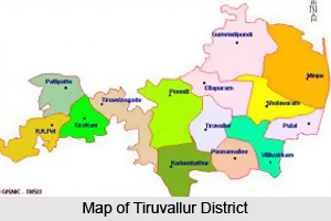
The Tiruvallur district has been carved out by the bifurcation of the erstwhile Chengalpattu district. As per the said bifurcation Tiruvallur revenue division which included Tiruvallur, Tiruttani taluks, Uthukkottai and Pallipattu sub-taluks separated from Chengalpattu district along with Ponneri and Gummindipoondi taluks of Saidapet revenue division formed this new district. Presently the Tiruvallur District is comprised of 8 taluks namely Ambattur, Gummindipoondi, Ponneri, Uthukkottai, Tiruvallur, Poonamallee, Tiruttani and Pallipattu, Madhavaram. The district of Tiruvallur possesses 3 revenue divisions which are Tiruvallur, Tiruttani and Ponnari. There are 3 taluks under Tiruvallur division, 2 taluks under Tiruttani divisions and 4 taluks under Ponneri division. There are 46 firkas and 820 revenue villages. Likewise there are 14 blocks, 6 municipalities and 19 town panchayats which implement rural development activities.
Demography of Tiruvallur District
As per the reports of Census India 2011, the total population of the Tiruvallur District was 3,728,104 with a sex-ratio of 987 females for every 1,000 males, much above the national average of 929. Children between the ages 0 to 6 years old were 405,669, thus constituting 208,449 males and 197,220 females respectively. When compared to the national average of 72.99 percent, the literacy rate of the Tiruvallur District was higher with 74.88 percent. The district had total of 946,949 households with the Scheduled Castes and Scheduled Tribes accounted for 22 percent and 1.27 percent of the total population respectively.
Education in Tiruvallur District
Since the Tiruvallur district is adjacent to the city of Chennai, there are remarkable numbers of Educational Institutions in the district. Several professional institutions particularly the veterinary university add honour to this district in the field of education. In the district, there are about 1542 schools. All the higher secondary schools are equipped with computer to impart computer literacy to the students and to the public.
Tourism in Tiruvallur District
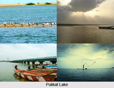
The Tiruvallur District has a very rich interesting history. It has many temples dedicated to various legends down the history. Basically an agriculture based district, it mainly contains village population with a few towns and some influence from the Chennai city. The major religion is Hinduism, though people following Christianity and Islam are there too. The temples are a rich heritage to the culture of this district and have many festivals unique to this region. One of the major festivals in this district is Periyapalayam Adi-Peruvizha which is celebrated for a period of 10 days. Other festivals are Tiruttani Adi-Kiruthikai Peruvizha, Tiruvallur Sri Veeraraghavar Temple Amavasya celebration, Mahalaya Amavasya day, etc. Some of the renowned places of interest in this district are Poondi Reservoir in Tiruvallur taluk), Pulicat Boating Center, Ambattur, Chembarambakkam, Avadi, Poovirundavalli, Pazhayanur, etc.
The presence of a number of academic institutions, business establishments, production units, religious monuments and temples enhances the strategic importance of the district of Tiruvallur in the state of Tamil Nadu. It is one of the newly-formed districts in the state of Tamil Nadu which was formed in the year 1997. Tiruvallur is the name of both the town as well as the district.


