 Ratnagiri district is a part of the Konkan tract situated in the state of Maharashtra. The district has nine tahsils with headquarters at Ratnagiri. Ratnagiri`s has been declared as the horticulture district in Maharashtra, as the warm and humid weather is most suitable for horticulture, especially for mango, cashew and jackfruit. The heavy rainfall results into highly eroded landscape in the coastal region. Fertile alluvial valleys produce rice and coconut as the main crops. The world-famous King of Mangoes, `Alphonso` is grown here. Ratnagiri`s cashew nuts are famous for earning dollars for Konkan. This district has produced three Bharat Ratna laureates- Dhondo Keshav Karve, P.V.Kane and Dr. B.R.Ambedkar. Lokmanya Bal Gangadhar Tilak was also born at Ratnagiri.
Location of Ratnagiri District
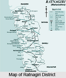
Ratnagiri district is located in the south-western part of Maharashtra State on the Arabian Sea coast. It is a part of the greater tract known as Konkan. It lies between 16. 98 degrees north latitude and 73.3 degrees east longitude. With a coastline of 237 Kms, the district stands at an altitude of 11 metres. Apart from the coast-line of the Arabian Sea forming its western limit, the Savitri river in the north separates, over the major portion, this district from that of Kolaba. The Sahyadrian scarp, ending abruptly in some places, also serves as a boundary between Ratnagiri on one hand and Satara district, Sangli and Kolhapur districts on the other.
History of Ratnagiri District
The district of Ratnagiri has had a rich history filled with many events. This region was under the rule of the Mauryas, the Nalas, the Silaharas, the Chalukyas, the Kadambas, the Portuguese, the Marathas and subsequently the British. In 1731 Ratnagiri came under the control of the Satara kings; in 1818 it was surrendered to the British. A fort was built during the Bijapur dynasty and strengthened in 1670 by the Maratha ruler Chatrapati Shivaji, which is located on a headland near the harbour. It is one of the ports of the Konkan coast. It has a palace where the last king of Burma, Thibaw and later Veer Savarkar were confined. It is also believed that the Pandavas of Mahabharata having performed their pilgrimage in the 13th year had settled in the adjourning territory of the Ratnagiri district and when the Pandavas and the Kauravas had the famous war at Kuruskshetra, the king of this region Veeravat Ray had accompanied them there. In 1948 the independent princely state of Sawantwadi was merged with the Indian union and in 1956 with Bombay Province. In 1960 with the creation of Maharashtra, Ratnagiri became a district. In 1981 Ratnagiri district was bifurcated and the new district of Sindhudurg was created.
Geography of Ratnagiri District
 Ratnagiri is a coastal district of Maharashtra state, situated in the western coast of India. It has a north-south length of about 180 km and average east-west extension of about 64 kms. Sahyadri hills surround it in the east beyond which there are the Satara, Sangli and Kolhapur districts, Raigad district in the north, the Arabian Sea in the west and Sindhudurg district in the south. Ratnagiri can be physically divided into 3 zones. These include the Coastal Zone, the Hilla area zone and the Middle zone. The coastal zone extends to about 10-15 km from seacoast and generally has low altitude and about 2500 mm rainfall. Most of the activities in this area are connected with sea. This area contains numerous beaches, creeks, sea forts, harbours, hot water springs, caves, temples and other religious places and places of scenic beauty. The Hill area Zone includes the western slopes of Sahyadri and extends up to about 10-15 kms. It generally has medium to high altitude with high rainfall of about 3500 mm. A large area in this zone is covered by forest although it is deteriorating very fast. A substantial drop in temperature is experienced at places exposed to the rising western breeze. This area contains hill forts, ghat roads, forests, wild life, etc. The Middle Zone area lies between the coastal and hill areas and generally has a medium altitude. It is more accessible due to the Mumbai-Goa-Highway as well as the Konkan railway.
Tourism in Ratnagiri District
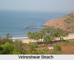
There are many places of rest and relaxation located in the district of Ratnagiri. These include a number of beaches since the seashore extend throughout the length of the district. Thus one can find here the Mandovi beach, Bhatye Beach and Velneshwar Beach where one can sit back and relax. Opportunities for water sports avilabale here can add a lot of excitement to the trip. Part for the beaches, there are also many places of pilgrimge here. These include the the Ganapatipule, Pawas and the Ganga of Rajapur. While the idol of Lord Ganesha at Ganapatipule is considered to be the Paschim Dwardevta, the Ganga of Rajapur exhibits a natural phenomenon that is considered a miracle by the locals. Every three year, 14 different pools of water of varying temperature are formed here, and this is considered to be a sign of the appearance of Ganga Mata to her devotees.


