 Kolhapur district is the southernmost district of Maharashtra. Its headquarters is at Kolhapur which is an ancient city. Kolhapur is the seat of Goddess Mahalaxmi and is one of the Shaktipeeths of India. Kolhapur was ruled by Silaharas, Yadavas, Rashtrakuta dynasty and Chalukya dynasty in the medieval times. The growth of the district in modern times is fascinating. Chhatrapati Shahu Maharaja is the architect and the founder of modern Kolhapur. The district is abundant in natural resources- water, soil, natural vegetation, animal wealth and minerals. As a result, Kolhapur is one of the most agriculturally advanced districts of not only Maharashtra but also India. It is fast becoming an industrialised district as well and is already a front runner in agro-based industries. Kolhapur district is one of the shining examples in the Co-operative Movement of India. The district has the highest per capita income in the Maharashtra State and one of the highest in the country. Kolhapur has a distinct culture developed as a result of a rich history and its quality of people who have been front-runners in various fields.
Location of Kolhapur District
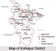
Kolhapur is a district newly formed after the merger of Kolhapur and other Indian States with the State of Bombay. It lies between 15 degrees and 17 degrees north latitude and 73 degrees and 74 degrees east longitude. It consists of 956 villages of the former Kolhapur State, five villages of the former Kurundwad State, one village of the former Miraj Senior State and seven villages that were formerly in the Belgaum district. It has an area of 3,188.4 square miles. It is bounded on the north by the district of Satara; on the west by the district of Ratnagiri and on the south and the east by the Belgaum district of Mysore State. For administrative purposes the district is divided into two parts, Northern and Southern.
History of Kolhapur District
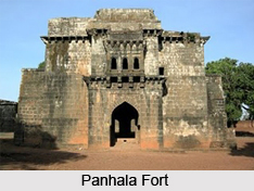
Kolhapur is famous from pre-historical times. Since 5000 years Kolhapur, has had trade relations with Rome and other countries. Evidences of the same can be seen in the Town Hall Museum. In the early 10th century, Kolhapur was the capital of the Shilahar dynasty. Many inscriptions are found in and around Kolhapur to provide evidence of the great kingdoms of the Kolhapur region. During the 11th century, Raja Bhoj the 1st built many forts in this region. The great king Chatrapati Shivaji extended his kingdom in the Konkan and Sanhyadri. Kolhapur region, lying on the boundary of Konkan and the other part of Maratha kingdom, Shivaji concentrated on this region. Forts like Panhala fort, Vishalgad, Bhudargad, Rangana, Shivgad, Gagangad etc. were specially constructed during Shivaji`s reign. Kolhapur continued to be the headquarters of many activities during the rule of the Marathas. In November 1710, Tarabai established a separate court at Panhala and declared it as a capital. During this period, Kolhapur saw many ups and downs. Kolhapur flourished in all the sectors such as art and crafts, sports, culture etc. under Chatrapati. Shahu Maharaj. In fact he is known as the architect of modern Kolhapur. His keen interests in development of agriculture and industry can even be seen in today`s era.
Geography of Kolhapur District
To a great extent, the landscape of the district of Kolhapur is influenced by the Deccan trap. Geographically, the district can be divided into three regions. This includes the Sahyadrian watershed region, the residual hill ranges and the river valleys. The district, on the whole, is a part of the Deccan table-land with an average height of 1800 ft. above sea level, with the Sahyadrian Scarp forming the most prominent feature along its western administrative boundary.  The climate of Kolhapur is temperate. In the western part of Kolhapur near the Sahyadris it is always cooler than that in the eastern part which is liable to hot winds during April and May. The nights over the whole district are generally cool due to the influence of the sea breezes which set in during the afternoons and continue till late in the evening.
Tourism in Kolhapur District
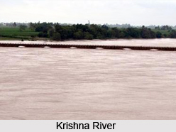
Kolhapur district has a number of attractive tourist spots to offer its visitors. Jungles, waterfalls, religious destinations, dams, hills, forts, etc. are scattered everywhere in the district. The plateau region lies along the eastern side in the basin of the Krishna River. This region of the district contains many religious tourist destinations such as Narsobawadi, Bahubali, Ranling etc. The western side of the districts is occupied by the Western Ghats mountain range. There are many forts situated here along the Sahyadri hills, such as the Panhala, Vishalgad, Shivgad, Bhudargad, Rangna, etc. The Radhanagari Wildlife Sanctuary has many species of plants and animals.


