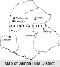
 Jaintia Hills District of Meghalaya is one of the seven administrative districts with its headquarters at Jowai. Jaintia Hills District came into existence in the year 1972. Jaintia Hills District covers a total area of 3819 sq km. This district of Meghalaya is surrounded by Assam in its east and north, by East Khasi Hills District in its west and by Bangladesh in its south. As per 2001 Census, total population of the district is 295,692. It includes majority of rural population.
History of Jaintia Hills District
The Jaintia Hills was originally known as Ka Ri Khadar Doloi. There were durbars of different denominations, like village durbar, Elaka Durbar, Syiem Durbar. Soon after the British took over the administration of the Jaintia Hills, they immediately abolished the office of the Syiem, though at the same time they retained the other two traditional institutions, that of the Doloi and Waheh Chnong or Village Headman. Thus the three tier system of administration which was in existence during the pre-British era was reduced into a two-tier system only. Under the British administration, the whole of Jaintia Hills along with few other villages of the Khasi Hills were grouped together under one common system of administration and they are treated as British areas and were administered directly by the British Government.
Geography of Jaintia Hills District
Geography of Jaintia Hills District is almost similar to that of Khasi Hills being a component of the Meghalaya Plateau. Jaintia Hills District has comparably more flat physiographical features with a mild gradient.
 The hills gently slope towards Brahmaputra valley of Assam in the north and overlook the plains of Bangladesh in the south. The Marangksih peak on the eastern plateau of Jaintia Hills District stands majestically at an elevation of 1631 metres from the mean sea level and is the highest peak in the entire district. The main elevation of this district of Meghalaya ranges between 1050 metres to 1350 metres. In general, the entire district is full of rugged and undulating terrains with the exception of the deep gorges, steep cliffs and narrow valleys carved out by several rivers and a good number of other turbulent streams. Geography of Jaintia Hills District is richly endowed with natural resources and with rich flora and fauna. The climate of Jaintia Hills District is remarkably pleasant yet rainfall profile is very high during the south-west monsoon, which usually starts from the middle of May and declines towards the last part of September. The district is very rich in natural resources.
Culture of Jaintia Hills District
Jaintias are the main inhabitants of Jaintia Hills District. Jaintias are known for their rich art and culture. Hand woven traditional costumes worn during dances and festivals will draw anybody`s attention. Cane, bamboo and wood are used for carving and engraving of various designs of craftworks. The popular festivals of Jaintia Hills District are Behdienkhlam festival and Laho Dance festival.
Tourism in Jaintia Hills District
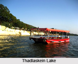
Jaintia Hills District offers several places of interest including some historical and religious sites. The charming scenic beauty as well the tourist attractions offered by the district are worth visiting. Letein Valley, Lechka Valley, Thadlaskein Lake, Kiang Nangbah Monument, Iale falls, Syntu Ksiar, Summer Palace of Jaintia Kings, Sutiang Fort, Borghat Temple, Umhang, Memjubel, Iawmusiang (largest Jaintia market located at Jowai) and Nartiang Temple are some of the major attractions of Jaintia Hills District.
Literacy Percentage of Jaintia Hills District according to 2001 Census is 53 percent out of which male literacy rate is 50.52 percent and female literacy ratio is 55.54 percent.


