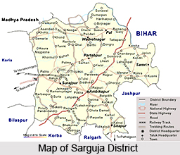
 Surguja District Surguja District lies between 23 degree and 37 minutes and 25 second to 24 degree 6 minutes17 seconds north latitude and 81 degree 34 minutes 40 seconds to 84 degree 4 minutes 40 seconds east longitude. 244.62 kilometres (152.00 mi) long east to west and 67.37 kilometres (41.86 mi) broad north to south, this land has as area of about 16,359 square kilometres (6,316 sq mi).
When it comes to the delineation of the geography of Sarguja District, the high-lands of Surguja district are characterised by peculiar `pat formations` which are but the highlands complimented with small tablelands. Several small areas mark the topographical chart of the place as for example Mainpat, the Jarang pat, the Jonka pat, the Jamira pat and the Lahsunpat that thrives to be the major parts of the district. The average height of area is above 600 metres (2,000 ft). Some of peaks are - Mailan 1,226 metres (4,022 ft), Jam 1,166 metres (3,825 ft), Parta Gharsa 1,159 metres (3,802 ft), Kanda Dara 1,149 metres (3,770 ft), Chutai 1,131 metres (3,711 ft), and Karo 1,105 metres (3,625 ft). There are a number of other peaks. North-west Surguja is hilly in nature, and moving westwards, three distinct steps may be marked out the first from Srinagar on the east to the lowlands of Patna and Khargawan, the second from thence to the uplands around Sonhat and the third beyond Sonhat to above a height of 1,033 metres (3,389 ft). Central Surguja is a low basin through which the Rihand and its tributaries flow.
There are three river basins in Suguja district - those of the Hasdeo River, the Rihand River and the Kanhar River. In winters, temperature dips to below 5 øC (41 øF) and in summers, it rises above 46 øC (115 øF). Main rivers of the district are Kanhar, Moran, Rihand River and Mahan. This drainage system is known as southward river system. The general slope of west Surguja is towards south and about 25% drainage comes in this system. Southerly rivers of district are the Hasdo and Gej, which forms the part of the Mahanandi Drainage System. This drainage system is called as southward river system. The general slope of west Surguja is towards south and about 25% drainage comes in this system. Southerly rivers of district are the Hasdo and Gej, which forms the part of the Mahanandi Drainage System.
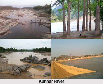
 Kanhar River starts its journey from Gidha-Dhodha on the Khudia plateau in jashpur tahsil of Raigarh district and flowing northward, forms the eastern boundary of district with Palamau district of Bihar state. This river flows for 100 Kms in district. It is fed by small tributaries - Suria, Chana, Sendur and Kursa on it`s left bank and Galphulla, Semarkhar, Riger and the Cherna nallah on it`s right bank . A number of waterfalls are located along the track of the river. Pavai fall near Kothali village (Balrampur District) is of about 61 meters. A plan for massive Hydro-electricity project was set up here since last two decades.
Rihand River has as Rend or Rehar, rises in the region southwest of the Mainpat plateau, which is about 1,100 meters above mean sea level, from Matiranga hills. The river flows north roughly through the central part of the district for 160 Kms. The Rihand and its tributaries form a fertile plain in the central district stretching around Ambikapur to Lakhanpur and Pratappur. It`s principal tributaries are the Mahan, the Morana(Morni) ,the Geur ,the Gagar ,the Gobri ,the Piparkachar , the Ramdia and Galphulla. A medium irrigation project is working on Ghungutta River, since 1981, near Darima Air Strip under taken by World Bank, Which is about 15 kms from Ambikapur. The Mahan is a perennial river, on which medium Multipurpose project is under implementation as well as consideration by Central water Commission.
Climate of Sarguja District
The climate of district features hot summer and well distributed rainfall during the monsoon season. With its general monsoonal character, the region according to thornthwait`s classification falls in the Tropical Thermal belt assigns it the grassland type character. According to trewartha`s classification, the Surguja falls in AW class, which is based on temperature and vegetation. The symbol AW denotes Tropical Swanah region. The chief feature of this climate is long dry period average monthly temperature rising over 18 0C, through maximum summer temperature may even go up to 46 0C. In winter the temperature not go below 18 degree Celsius .The monsoon bring sufficient rains. The chief determinants of climate in the district are its shape, Size, extent, and Central system of high lands and uplands. The location on tropic of cancer results tropical climate with high-pressure belt throughout the year, but due to its height above MSL controls its high temperature. The district is about 700 km from ocean therefore oceanic effect still remains zero , Whereas it`s location southward of Himalaya about 500 km protects it against cold winds blowing from northern belt.
Physiography of Sarguja District
The Physiography of the Sarguja District is divided into three broad natural divisions- the Mountains, Plateaus and the Central Plain. Physiographically, they are remarkable landforms and difficult to find a large area of one character expects its attitude .Average height of area is varies from 600 meter and more. The highland of Surguja district is peculiar `pat formations`. The major peaks of the district are as under: The Mainpat, the jarang pat, the jonka pat, the jamira pat and the Lahsunpat are the major pats of the district. The Uplands (Plateaus and hills): The terrain of northwest Surguja region is marked by hilly areas and there the roads move westwards. Three distinct steps may be marked out the first from Srinagar on the east to the lowlands of Patna and Khargawan, the second from thence to the uplands around Sonhat and the third beyond Sonhat to above the height of 1,033 metres. The Central plain and lowlands includes the topography central Surguja assume the form of low basin through, which the Rihand and its tributaries flow. This low-level basin is in form of inverted triangle.


