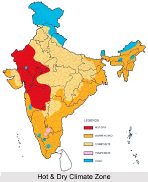
 The hot and dry climate in India prevails in north-western region of the country mainly from April to June and in the rest of the country from March to May. This climate of the country is characterized by dryness and excessive heat almost throughout the country. Generally the temperature varies from 30 to 32 degrees Celsius in almost all parts of India. From March onwards, the interior of Peninsular India starts to grow warmer. When the vertical rays of the sun advance towards the Tropic of Cancer, temperature basically rises in northern India. By mid-May, mean monthly temperatures over the country are high and are almost above 32 degree Celsius.
Coastal plains of India generally have the mean maximum temperature below 38 degree Celsius, owing to their closeness to the sea. However, temperatures as high as almost 48 degree Celsius are also recorded in the plains of north-western and central India. Plateaus and hills are relatively cool because of high altitude. In India, except for coastal areas and highlands, temperature across the country is surprisingly uniform in the month of May. At that time, isotherm encloses most of the portions of the country. Like for instance, it runs from eastern Kutch to Gulf of Cambay. From there, it turns towards south running east of the Western Ghats and the Karnataka Plateau before reaching the southern part of Andhra Pradesh. Thus, it runs along the east coast by taking a turn towards the north-west from western Bihar. East and south India is comparatively less hot in the month of June because of the onset of rainy season.
However, north and west India is hottest in June. During May, which is the hottest month of southern India, temperatures on the east coast are relatively higher than those on the west coast by near about 3 degree Celsius. In March, the highest temperature of near about 38 degree Celsius occurs in Deccan Plateau and in April, temperature varying between 38 degree Celsius and 43 degree Celsius are common in Gujarat and Madhya Pradesh. In the month of May, the heat belt moves towards north, and in the country`s north-western part temperature reaches around 48 degree Celsius. However, the peninsular condition of southern region of India with modest effect of the oceans keeps the temperatures comparatively lower than that in northern region of India. Thus, the temperatures remain between 26 degree Celsius and 32 degree Celsius.
The hot and dry climate of India is dry especially in coastal plains. However, sea breeze brings moisture from the sea owing to the proximity to the sea. Eastern India too has some moisture in the air. The instability is caused due to strong surface heating and wherever sufficient moisture is present, thunderstorms are occasionally caused though these thunderstorms are short lived. They generally originate in the Chota Nagpur Plateau and its adjoining areas. Thunderstorms are however not very common in north western India during the hot and dry season. Moreover, in north western India westerly depressions also cause a little rainfall. In this region, dust storms are prevalent. The dust storms are active usually from midday to a little before sunset. Sometimes, unusually strong dust-laden winds blow continuously for a few days.
Further, hot and dry climate dries up some of the tanks and wells across the country. At this season, drinking water becomes scarce at some places specifically in South India, Western India and Central India. Depleted water supplies affect the production of hydro-electric power adversely. Thus, it can be said that the hot and dry climate means huge rise in the temperature with bad effects in every sphere of the country.


