 Wayanad district is situated on the southern top of the Deccan plateau. Its prime feature is the Western Ghats mountain range, standing tall with lofty ridges and interspersed with dense forest, tangled jungles and deep valleys. The terrain is generally rugged. The district of Wayanad occupies a total area of 2132 Sq. Kms. The district lies between 11 degrees 27 minutes and 15 degree 58 minutes north latitude and east 75 degrees 47 minutes and 70 degrees 27 minutes. It is bounded on the east by Nilgiris and Mysore districts of Tamil Nadu and Karnataka respectively, on the north by Coorg district of Karnataka, on the south by Malappuram and on the west by Kozhikode district and Kunnur district.
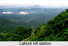
Wayanad district has quite a healthy climate. The mean average rain fall in this district is 2322 m.m. Lakkidi, Vythiri and Meppadi are the high rainfall areas in Wayanad. Annual rain fall in these high rain fall areas ranges from 3,000 to 4,000m.m. High velocity winds are common during the south west monsoon and dry winds blow in March-April. High altitude regions experience severe cold. In the district, Ambalavayal experiences a high relative humidity which goes even up to 95 per cent during the south west monsoon period. Generally, the year is classifed into four seasons, namely, cold weather (December-February), hot weather (March-May), south west monsoon (June-September) and north east monsoon (October-November). The dale, `Lakkidi`, nestled among the hills of Vythiri taluk has the highest average rainfall in Kerala. The average rain fall in Wayanad is 300mm. per year. There is a decreasing trend in rainfall in this area. The average rainfall data shows that the lowest rain fall received from north east monsoon is in Wayanad district. 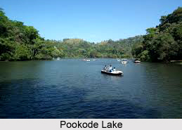
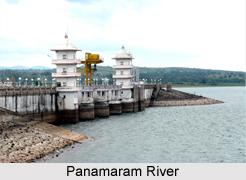
The Kabani River and its tributaries make up a rather powerful river system in the landscape of Wayanad district. Kabani is an important tributary of the Kaveri River and one of the three east-flowing rivers of Kerala. Panamaram rivulet takes its origin from the perennial lake called, `Pookode Lake`. It flows swiftly through mountain gorges and joined by other streams, tumbles down into Panamaram valley. Six kilometres further from Panamaram, this river joins with the Mananthavady rivulet, originating from the lower regions of the peak `Thondarmudi`. From this confluence onwards, the river is known as Kabani, a mighty, perennial river which after entering Karnataka state, joins with the Kaveri River. Almost the whole of Wayanad is drained by the Kabani River and its tributaries, namely, Panamaram river, Mananthavady river and Thirunelli river.
 The vegetation of the district of Wayanad is typical of the Western Ghats and the plantation crops grown in the cool climate. A major portion of the district is covered by coffee. Among the trees found here are rosewood, anjili (Artocarpus), mullumurikku (Erthrina), several species of Cassia and many other non-descript varieties which have been preserved to give shade to the coffee plants. In a majority of coffee plantations, the age-old species are replaced by the silver-oak which is suited to the cold climate. It is also used for the plywood industry and thus is economical to the farmers. Eucalyptus grandis, a shorter variety of eucalyptus, whose fragrant smell suffuses the very air around it, is cultivated on a large scale in certain parts of the district. Eucalyptus oil is extracted on commercial basis from its leaves. Of the 20,864 hectares of reserve forest, the major portion is teak plantation. Arecanut palms and jack trees are also grown here. Tea is grown as an industry in large estates. The soil and climate of Wayanad are suitable for horiculture on a commercial basis. With the clearing of forests, animal life of the forests has been on the decline. Among the animals found here are bonnet monkeys, loris, mongoose, jungle cats, squirrels, jackals, hares, etc. in the limited forest areas.


