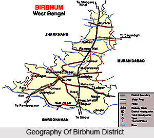
 Birbhum district is situated in the state of West Bengal. The northernmost district of the Burdwan division, it lies between 23 degrees 32 minutes and 24 degrees 35 minutes north latitude and 88 degrees 1 minute and 87 degrees 5 minutes east longitude. In shape it looks like an isosceles triangle. The apex is situated at the northern extremity not far south of point where the Ganga River and the hills of the Santhal Paraganas begin to diverge while the Ajay River forms the base of this triangle. Birbhum is bounded on the north and west by Santhal Paraganas, on the east by the districts of Murshidabad and Burdwan and on the south by Burdwan, from which it is separated by the Ajay River. The district extends over an area of 4545 Sq. Kms.
The climate of the district is generally dry, mild and healthy. The hot weather usually lasts from the middle of March to the middle of the June, the rainy season from the middle of June to the middle of October, and the cold weather from middle of October to the middle of March. It must be noted that they do not always correspond to these limits. As a rule, the wind is from south-east in summer and from the north-west in winter.
Birbhum district is well drained by a number of rivers and rivulets which run in from West to East with a slight inclination towards the South. There are only two rivers here which are of any magnitude, the Mor River and the Ajay River. Ajay marks the Southern boundary whereas the Mor runs through Birbhum from West to East. Both rivers are of considerable size when they enter the district, their width varying according to the configuration of the country, from two hundred yards to half a mile. The Ajay first touches the district at its south-west corner, and follows a winding course in an easterly direction, till it enters Burdwan at the extreme south-eastern angle of Birbhum, eventually falling into Bhagirathi River near Katwa. The Mor enters Birbhum from the Santhal Paraganas near the village of Haripur and flows through the centre of the district from west to east, passing two miles north of Shiuri and forming the southern boundary of the Rampurhat Sub-division. It leaves the district a little east of Gunutia and joins Dwarka which itself is a tributary of the Bhagirathi. The Mor is also widely known as Mayurakshi meaning "the peacock eyed", i.e. having water as lustrous as the eye of the peacock. Between the Mor and Ajay there are a few large streams coming from beyond the western boundary, of which the Hinglo is the most important. It enters the district from the Santhal Paraganas some eight miles north of Ajay, flows through Dubrajpur thana, and gradually approaches that river, unites with it at Chapla, after a course in Birbhum of about 15 miles. Another river is the Bakreswar, which rises at a hot spring of the same name near Tantipara, some ten miles west of Suri, and after following a zigzag course eastward, and receiving one by one the waters of almost all the rivulets, joins the Mor a few miles beyond the eastern boundary of the district. Other important rivers of the district include the Brahmani River, the Bansloi, the Pagla River, and the Kopai River or Sal River.
The eastern portion of the district is a continuation of the rice plain of West Bengal, and the vegetation is characteristic of rice fields in Bengal. Generally, species of Aponogeton, Utricularia, Drosera, Dopatrium, Ilysanthes, Hydrolea, Sphenoclea and similar aquatic or palustrine genera are abundantly found. In the drier undulating country to the west the characteristic shrubs and herbs include species of Wendlandia, Evolvulus, Stipa, Tragus, Perotis, Spermacoce, Zizyphus , Capparis and other similar plants affecting a laterite soil. Trees like mango tree, palm, and bamboo are frequently found. Other abundant species are jack, arjun, sal, piar, dhau, kend and mahua.
The carnivores of the district include leopards, bear, Bandarsol and Charicha. Wild elephant from nearby Santhal Paraganas (now Jharkhand) migrate into the district in search of food and sometime in attraction of Mahua flower. Apart from these, long tailed apes, called Hanuman are commonly found. They often damage growing crops in the villages. The birds commonly found in the district include partridges, green pigeons, and various water fouls. But their numbers have dwindled considerably due to reckless hunting. Few migratory birds are also found near Bolpur. Common birds of deltaic Bengal are mixed up in this district with birds of wooded hill. Doyel, Indian robin, drongo, hawk, cuckoo, koel, sun bird, Indian roller (nilkantha), parrot and babblers are found in abundance. The major verities of fish include rui and katla which are found in rivers. There are numerous tanks in the district which are stocked with rui, katla, mrigel, magur and koi.


