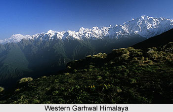
 East of the Bhagirathi River is the region of Western Garhwal Himalaya, which is more easily reached from Har-ki-doon and the Tons river. It is considered as a most attractive climbing arena comprising the Swargarohini (I-IV) and the Bandarpunch peaks - White Peak (6102 m), Ban-darpunch (6316 m) and old black peak Kalanag (6387 m). Interestingly, this region first came into prominence when the Doon School masters - R. L. Holdsworth, J. T. M. Gibson, J. A. K. Martyn and Gurdial Singh - used this area to offer climbing experience to their wards during summer holidays. In fact, the first ascent of Bandarpunch in the year 1950 was by Jack Gibson and other young climbers. Since then the Nehru Institute of Mountaineering has taken its students to the area, and they also climbed the peak in the year 1975. Gibson and his boys also made the first ascent of Kalanag in the year 1955. The tradition was continued by Hari Dang (ex-pupil, now master in the Doon School) who led another summit party in the year 1968 to Kalanag, which is regarded as an excellent area for training youngsters to climb and ski.
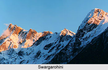 It is not only Swargarohini but all the peaks of the Western Garhwal region are considered beyond the capabilities of beginners. Swargarohini II (6247 m) was climbed by the Canadians (Virk and Clarke) in the year 1974 and again by a Bombay team (Anil Kumar) in the year 1985. Two more Indian ascents were made when a Bombay party (headed by R. Wadalkar) teamed up with an Oil and Natural Gas Commission expedition to reach the top. Swargarohini III (6209 m) was also climbed (its first ascent) by the Bombay party in the year 1985. Swargarohini I (6252 m) is an extremely tough proposition, which is still awaiting its first ascent. Climbing prospects in Western Garhwal region is defined as difficult and impossible. So many peaks in this region of the Himalaya Mountains remain unclimbed merely because they are unnamed and therefore they are of less publicity value. If ever someone just numbers the peaks with their heights one will need to use five figures before the last one is awarded its place. It is said that the keen climber requires little imagination to stoke up the attempt to explore Garhwal.
Western Garhwal region thus offers numerous scopes of exploration and adventure.


