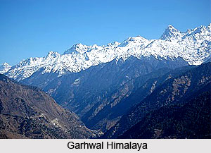
 Garhwal Himalaya forms the center part of the Himalaya Mountains. Garhwal is considered as the land of several forts. Garhwal Himalayas symbolizes a spiritual truth beyond the general principles of the common man. This quality has attracted sages and pilgrims for limitless centuries. Central Garhwal consists of the mountain area around the Saraswati-Alaknanda river system and the Dhauli valley. The Dhauli after joining up with the Rishi Ganga (emerging from the protection of the Nanda Devi Sanctuary) eventually joins the Alaknanda at Joshimath. The region is of some considerable significance in Hindu mythology, and Badrinath on the Alaknanda is one of the four holy places of pilgrimage - the others being Kedarnath, Jamnotri and Gangotrii. The exploration and mapping of this region started, as usual, with the survey parties from the Survey of India.
Garhwal is the birthplace of two most holy rivers of Hinduism - Ganga River and the Yamuna River. Moreover, this is the place of the char dhams, which means the four Himalayan shrines that have attracted Hindu pilgrims for centuries. There are several great peaks that rise majestically at the Garhwal Himalaya region like the Kamet, Nanda Devi and Trishul. They are separated by the rivers of northern India. Kamet (7756 m), the prominent point of this area, was surveyed by R. Strachey in the year 1848 and soon after that, climbing attempts began soon after. The Schlagintweits came in 1855 and named the peaks Western, Central and Eastern Ibi Gamin, which are identifiable today as Mukut Parbat (7242 m), Kamet and Abi Gamin (7355 m). Mana (7272 m) was also visited. Between 1910 and 1914 several attempts were made to explore Kamet. Next to Kamet, there lies Abi Gamin that was first climbed in the year 1950 by a team comprising R. Dittert, K. Berril, A. Tissieres and G. Chevally, who approached from the north. Since then, it has been climbed several times.
There were only a few expeditions to Central Garhwal before the 1950s but the major ones did some excellent field work. The first to come was the indomitable Frank Smythe in 1937. He had already visited the Bhyundar valley in 1931 (after the Kamet expedition) and had very appropriately named it The Valley of Flowers, a botanist`s paradise. In the year 1950, a Scottish team under W. H. Murray crossed the Girthi gorge, a tributary of the Dhauli. They trekked in the Siraunch valley and crossed the Unta Dhura (pass) into Kumaon. Apart from climbing some unnamed peaks in the northern rim of the Nanda Devi Sanctuary, they made the first ascent of Uja Tirche (6202 m) and attempted Lampak (6325 m). It was described as an extremely well traveled expedition.
With this expedition the first phase of exploratory climbing was over; the second phase is still in progress where the smaller valleys with challenging peaks of modest height wait to be visited. Meanwhile some of the major ascents in this area have been those of Mukut Parbat (7242 m) by New Zealanders in the year 1951, Hathi Parbat (6727 m) in the year 1963 by an I.T.B.P. team and Ganesh Parbat (6532 m) in the year 1965 by the Indian Police. A word or two on a small selection of peaks to the west of the Saraswati-Alaknanda divide peaks that can be reached from Badrinath on the main road. There are two summits named Avalanche Peak. The first one lies on the Bhagnyu glacier (6196 m) and its avalanche caught early visitors T. H. Tilly and John Jackson in the year 1952.
Nanda Devi, which is a part of the Garhwal Himalayas, is described as the crowning glory of Garhwal. The awe-inspiring peaks, the beautiful valleys and meadows, the strong rivers and the legends aptly describe Garhwal Himalaya.


