Located in Bellary District, northern Karnataka, Vijayanagara is the name of the now-ruined capital city. The city is situated in magnificent surroundings, and its most striking element is the river Tungabhadra that flows here in a north-easterly direction through rugged rocky terrain, particularly inhospitable on its northern bank.
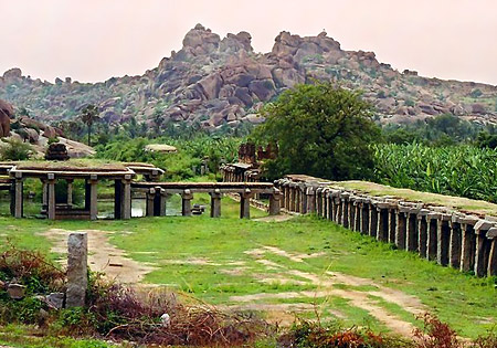
The Vijayanagara city is furnished with pinkish-grey granite boulders form fantastic formations as though piled up by some mysterious spirit. To the south of the river are two ridges, separated by a valley, and low hills such as Hemakuta and Matariga. Immediately south of these, the landscape changes, giving way to open valleys with isolated rocky outcrops, including Malyavanta hill. The remains of the city of Vijayanagara, popularly known as the `Hampi ruins,` are spread over an extensive area of about 25 square kilometres, from the village of Hampi in the north to Kamalapuram in the south. The outer lines of its fortifications and the suburban areas, however, include a much vaster area, from Anegondi in the north to the modern town of Hospet in the south.
 The discovery of neoliths and handmade pottery at the site proves that the history of the Hampi region dates back to Neolithic times. Later this area came under the control of various dynasties that ruled Karnataka successively, including the early Western Calukyas, the Calukyas of Kalyani, the Hoysalas and so on. This site, from pre-Vijayanagara times, has an unbroken tradition of sanctity. It is a place of pilgrimage hallowed by the goddess Parhpa and her consort Virupaksa. Kiskindha of the Ramayana is also believed to be close to Hampi and certain incidents of this epic are said to have taken place in and around this area. To facilitate documentation at the site, the entire area has been divided into four functional zones: the `sacred centre`, the intermediate `irrigated valley`, the `urban core` and the `sub-urban centres`.
The `sacred centre` is to the south of the Tungabhadra. Here, in the confined areas of flat land or at the summits of rocky outcrops, are located the largest temple complexes of the city, numerous smaller temples and shrines, sculptures and inscriptions. To the south of this is the `irrigated valley`, where the paucity of buildings and potsherds indicate that this was an agricultural zone. The `urban core` occupies a series of hills, ridges and valleys to the south of the agricultural zone. The greatest concentration of population was once located here, as is proved by the traces of residences, tanks, wells, roads, stairways, pottery and also of the remains of many small shrines and larger temples. In the south-west end of the `urban core` is the `royal centre`, which had its own enclosure wall, only parts of which have survived. To the north, the `urban core` is bounded by the `north ridge`. In the east end of the `north ridge` and the north-east valley below it was the main Muslim quarter of the city. Laid out beyond this zone, further south and west, as far as modern Hospet, were the great residential suburbs. A few isolated temples in these areas are all that remain of the once populous `sub-urban centres`.
Inscriptions and literary sources supply information about some of the quarters, suburbs, canals, markets, gates and so on, many of which date from the sixteenth century. The area around the great Virupaksa temple complex was known as Virupaksapura or Hampi while the Vitthala temple was located in Vitthalapura. On his return from the victorious Udayagiri campaign, Krisnadevaraya installed in the Krisna temple in Krisnapura the image of the child Krisna that he had brought from Udayagiri. Kamalapuram was known by that name at least from 1531 AD onwards. The Tiruveiigalanatha temple complex was in Acyutarayapura. The names of some of the suburbs (Nagaladevi-pura, Tirumaladevi-ammana-pattana, Sale-Tirumala-maharaya-pura and Varadadevi-ammana-pattana) to the south of the main city, built by Krisnadevaraya and Acyutaraya, are also known.
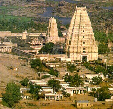 The monuments within the city consist mainly of religious, civil and military buildings. The religious structures include small shrines, large temple complexes, monastic establishments and sculptures. The bulk of the temples belong to the Vijayanagara period, a small proportion is assigned to pre-Vijayanagara times and these are mostly located in the original pilgrimage centre at the site that is, on Hemakuta hill and in and around the Virupaksa temple complex. There are hundreds of small shrines and some large temple complexes within the city dating from the Vijayanagara period. The shrines, comprising only a cella, or a cella and porch, or a cella, small mandapa and porch, are found all over the site. The temple complexes are mainly restricted to the `sacred centre`, though each suburban area also has one large temple.
Many of the temples and other monuments are adorned with sculpture. A large number of non-religious themes soldiers on horseback, clowns, acrobats, wrestlers, dancers, animals, birds and so on are incorporated into the sculptures. The variety of deities depicted, often not strictly according to the canonic texts, and the large number of non-religious themes represented indicates innovations in and new interpretations of the iconographical rules that guided artists in the earlier periods. Besides the sculptures on monuments, there are also a vast number of reliefs carved on free-standing boulders as well as a few monolithic statues.
Besides the Hindu and Jaina temples and sculptures, there are also the remains of a number of Muslim tombs, gravestones and at least two mosques. Contemporary with the religious monuments are secular structures of different types. Among these are some that employ easily recognizable Islamic elements such as arches, domes and stucco decoration. The most important of these are the so-called `Lotus Mahal`, the `Queen`s Bath`, the `Guards` Quarters` and the `Elephant Stables`. These buildings demonstrate an effective synthesis of different architectural styles, for despite using Islamic elements, they are neither Islamic nor Hindu, but are typically Vijayanagaran. This was an imperial style reserved for buildings connected with the king, court and army.
Besides the innumerable sculptural representations revealing the practice of dance and music, there are certain structures within the large temples that also indicate the prevalence of performances. These representations reveal that the people of Vijayanagara patronages of art and culture. Dance and music were integral components of social life, temple rituals as well as the court festivals at Vijayanagara. During the festivals the male and female people of Vijayanagara perform dances accompanied the processional deities when they were taken out of the inner sanctum. The inscriptions from the Vitthala temple mention that the processions of the deities were to be accompanied by the male and female musicians and dancers of the temple. This also makes it clear that there were both male and female musicians and dancers.
The destruction of this rich and splendid city was sudden and dramatic. Following the battle at Talikota, Vijayanagara was first looted by robber bands and then systematically plundered by the victorious allied Deccan armies. The large quantities of charcoal found during the archaeological excavations prove that parts of the city were burnt, while the mutilated sculptures render mute testimony to the iconoclastic zeal of the invaders. However, no longer being the setting of a royal dynasty, the city soon fell into decay. Later treasure-seekers and vandals have added to the despoliation of the site and the forces of nature have continued the work of ruination begun by man.


