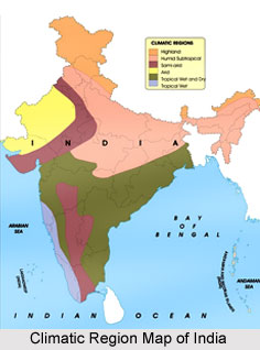
 Indian climatic regions are groups of climatic regions in the country. There are large variations in Indian climate from region to region, due to the country"s vast size. This variation in climate has given rise to Indian climatic regions and has been the most significant factor in developing tourism in Indian states. India has 3 major climate groups. These climate groups can be subdivided into 7 climatic types.
Tropical Rainy Climate Group
Tropical Rainy Climate Group is a climatic region that experiences persistent high temperatures, which normally do not go below 18 degree Celsius even in the coolest month. There are two climatic types which fall under this group. They are the tropical monsoon rain forest climate and the tropical wet and dry climate.
•Tropical Monsoon Rain Forest Climate: Tropical Monsoon Rain Forest Climate is experienced by the Western Ghats Mountain Range in India, west coastal lowlands and southern parts of Assam. It is characterized by high temperatures throughout the year, even in the hilly regions. The rainfall in these regions is seasonal, but heavy and is above 200 cm in a year.
•Tropical Wet and Dry Climate: Tropical Wet and Dry Climate is experienced by most of the plateau of peninsular India, except a semi-arid tract to the east of the Western Ghats. Winters and early summers are extensive dry periods with temperatures above 18 degree Celsius. The rainy season is from June to September and the annual rainfall is between 75 and 150 cm.
Dry Climate Group
Dry Climate Group is the Indian climatic region where the rate of evaporation of water is higher than the rate of moisture received through precipitation. It is subdivided into 3 climate types, namely the tropical semi-arid steppe climate, sub-tropical arid desert climate and sub-tropical semi-arid steppe climate.
•Tropical Semi-Arid Steppe Climate: Tropical Semi-Arid Steppe Climate is experienced by a long stretch of land situated to the south of Tropic of Cancer, east of the Western Ghats and the Cardamom Hills. These regions comprise a famine prone zone with very unreliable rainfall. The rainfall varies between 40 and 75 cm, annually.
•Sub-Tropical Arid Desert Climate: Sub-Tropical Arid Desert Climate is experienced in maximum portion of western Rajasthan. Very inconsistent and scanty rainfall of less than 30 cm characterizes sub-tropical arid desert climate. It is also important to note that for several years a few regions may not even experience rainfall. Summers are very hot. During the winter months, cold waves are experienced.
•Sub-Tropical Semi-Arid Steppe Climate: Sub-Tropical Semi-Arid Steppe Climate is experienced towards the east of the tropical desert from Punjab and Haryana to Kathiawar in India. This climate is intermediary as it lies between tropical desert and humid sub-tropical conditions. The annual rainfall ranges between 30 and 65 cm. There are chances that the maximum temperature of about 45 degree Celsius may be reached during summers and during winters, temperature may fall down to freezing point.
Sub-Tropical Humid Climate Groupt
Sub-Tropical Humid Climate Group experiences temperatures ranging between 18 and 0 degree Celsius, during the coldest months. The climate group has 2 subdivisions in India, namely the sub-tropical humid with dry winters and the mountain climate or highland climate or alpine climate.
•Sub-Tropical Humid with Dry Winters Climate: Sub-Tropical Humid with Dry Winters Climate is experienced by the foothills of the Himalayan Mountain Range, Punjab-Haryana plain adjacent to the Himalayas, Rajasthan (east of the Aravalli Mountain Range), Uttar Pradesh, Bihar, northern part of West Bengal and Assam. The rainfall is received mostly in the summers and is about 65 cm in the west and increases to about 250cm annually to the east and near the Himalayas. The summers are hot and temperature of about 46 degree Celsius can be reached in the lowlands. The winters are usually dry due to the land deriving winter winds which blow descending the lowlands of north India towards the Bay of Bengal. May and June are the hottest months. Winter months are mostly dry with slow winds. Frost occurs for a few weeks in winters. The difference in rainfall between the east and the west gives rise to a wide difference in the natural vegetation and crops.
•Mountain Climate: Mountain Climate is experienced in the Himalayan Mountains. This climate is characterized by temperature falling by 0.6 degree Celsius for every 100 m rise in altitude and this gives rise to a variety of climates from nearly tropical in the foothills to tundra type above the snow line.


