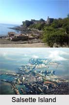
 Salsette Island is one of the beautiful islands of India and the cities of Thane and Mira-Bhayandar lie on it. It is very crowded and fourteenth most compactly populated islands in the world. It is comprises of lakes, rivers and bays. People come here to take rest and relax themselves. The word "Sasashti" is Marathi for "sixty-six," referring to the original "sixty-six villages" on the island.
Location of Salsette Island
Salsette Island is included in Maharashtra state and lies on the western coast of India. It is surrounded on the north by Vasai Creek, on the northeast by the Ulhas River, on the east by Thane Creek and Bombay Harbour, and on the south and west by the Arabian Sea. Politically, most of the island falls into the municipality of Mumbai. The municipality is divided into two separate districts, Mumbai City and Mumbai Suburbs.
Geography of Salsette Island
Bandra, Juhu, and an old linear sand bar set on the western side of Salsette Island. The island is at the convergence of a number of fault lines. It is the earthquake-prone area, up to a magnitude of 6. It is mostly composed of black basalt rock. There are three foremost lakes on the island namely Powai Lake, Tulsi Lake and Vihar Lake. There are rivers like Mithi River, Poisar River, Oshiwara River and Dahisar River etc. North of this region lay vast amount of confined wetlands at Sewree which is a home to migratory birds.
History of Salsette Island
Salsette Island was occupied by the farmers who mark out their adaptation of Christianity back to 55 AD with the arrival of Christ"s follower St. Bartholomew in north Konkan, Maharashtra. They were switched to Roman Catholicism by four religious orders like Dominicans, Franciscans, Augustinians and Jesuits. It was ruled by a series of Hindu kingdoms.
In 1343, the island was annexed by the Muslim Sultanate of Gujarat. In 1534, Portuguese took the island from Sultan Bahadur Shah of Gujarat. It became part of the northern region of Portuguese India. In 1554, the island was handed over to Garcia de Orta, a famous physician and botanist. In 1737 the island was captured by the Marathas. Britishers occupied Salsette Island in 1774. By 1901 the population of Salsette enlarged to 146,993 and the area began to be known to as Greater Bombay.
Presently The Salsette Island includes 109 Buddhist caves dated back to 2nd century and the caves are similar in structure to that of Kanheri caves. The beautiful blue sea water of Arabian Sea presents ample opportunities to the tourists for entertainment and enjoyments.


