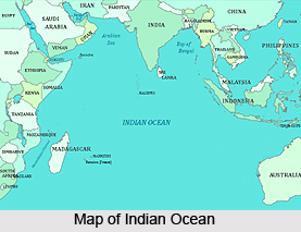
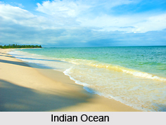
 The Indian Ocean happens to be the third largest of the world`s oceanic divisions, covering about 20% of the water on the Earth`s surface. This ocean is bounded on the north by Asia, including the Indian subcontinent, after which it is named. On the west it is surrounded by Africa, on the east by Indochina, the Sunda Islands, and Australia; and on the south by the Southern Ocean or Antarctica.
The Indian Ocean is separated from the Atlantic Ocean by the 20° east meridian running south from Cape Agulhas, and from the Pacific by the 147° east meridian. The northernmost expansion of the Indian Ocean is approximately 30° north in the Persian Gulf and, thus, has asymmetric ocean circulation. Indian Ocean is nearly 10,000 kilometers (6,200 mi) wide at the southern tips of Africa and Australia; its area is 73,556,000 square kilometers (28,400,000 mi²), including the Red Sea and the Persian Gulf.
The Indian Ocean`s volume is estimated to be around 292,131,000 cubic kilometers (70,086,000 mi³). Small islands dot the continental rims. Island nations within the Indian Ocean are Madagascar (formerly Malagasy Republic), the world`s fourth largest island; Comoros; Maldives; Seychelles; Mauritius; and Sri Lanka. Indonesia borders the Indian Ocean on the east. The ocean`s importance as a transport route between Asia and Africa has made it a scene of conflict. Because of its size, however, no nation had successfully conquered most of it until the early 1800s when the United Kingdom controlled much of the surrounding land. After the decline of the British Empire, the Indian Ocean was dominated by India and Australia
The African, Indian, and Antarctic crystal plates unite in the Indian Ocean. Their junctures are made distinct by branches of the Mid-Oceanic Ridge forming an inverted Y, with the stem running south from the edge of the continental shelf near Mumbai, India. The eastern, western, and southern basins thus created are subdivided into smaller basins by ridges. The ocean`s continental shelves are narrow that average upto 200 kilometers (125 mi) in width. An exception is however found off Australia`s western coast, where the shelf width exceeds 1,000 kilometers (600 mi). The average depth of the ocean is 3,890 metres (12,760 ft). Its deepest point is in the Java Trench. North of 50° south latitude, 86% of the main basin is covered by pelagic sediments, of which more than half is globigerina ooze. The remaining 14% is layered with terrigenous sediments of the Indian Ocean. Glacial outwash dominates the extreme southern latitudes.
A spring 2000 the International Hydrographic Organisation decided to de-eliminate a fifth world ocean, stripping the southern portions of the Indian Ocean. The new ocean extends from the coast of Antarctica north to 60° south latitude, which coincides with the Antarctic Treaty Limit. The Indian Ocean remains the third largest of the world`s five oceans. Major choke points include Bab el Mandeb, Strait of Malacca, Strait of Hormuz, southern access to the Suez Canal, and the Lombok Strait. Seas in Indian Ocean include Andaman Sea, Arabian Sea, Great Australian Bight, Bay of Bengal, Gulf of Aden, Gulf of Oman, Laccadive Sea, Mozambique Channel, Persian Gulf, Red Sea, Strait of Malacca, and other tributary water bodies.
 The climate of Indian Ocean is same to that of the north of the equator that is affected by a Monsoon climate. Strong northeast winds blow from October until April; from May until October south and west winds prevail. In the Arabian Sea the brutal Monsoon brings rain to the Indian subcontinent. In the southern hemisphere the winds are generally milder, but summer storms near Mauritius can be harsh. When the Monsoon winds change, cyclones sometimes hit the shores of the Arabian Sea and the Bay of Bengal. The Indian Ocean is said to be the warmest ocean in the world.
Few large rivers flowing into the Indian Ocean are the Zambezi, Shatt al-Arab, Indus, Ganges, Brahmaputra, Juba and Ayeyarwady River. Currents of this ocean are mainly controlled by the monsoon. Two large circular currents, one in the northern hemisphere flowing clockwise and one south of the equator, moving anticlockwise, constitute the leading flow pattern. During the winter monsoon, however, currents in the north of Indian Ocean are reversed. Deep-water circulation is controlled primarily by inflows from the Atlantic Ocean, the Red Sea, and Antarctic currents. Southward of 40° south latitude, temperatures drop down quickly. Surface water salinity ranges from 32 to 37 parts per 1000, the highest occurring in the Arabian Sea and in a belt between southern Africa and southwestern Australia. Pack ice and icebergs are found throughout the year in south of about 65° south latitude of Indian Ocean. The average northern limit of icebergs is 45° south latitude.
The Indian Ocean enjoys major sea routes connecting the Middle East, Africa, and East Asia with Europe and the Americas. It carries a particularly heavy traffic of petroleum and petroleum products from the oil fields of the Persian Gulf and Indonesia. Large reserves of hydrocarbons are being tapped in the offshore areas of Saudi Arabia, Iran, India, and Western Australia. An estimated 40% of the world`s offshore oil production comes from the Indian Ocean. Bordering countries, particularly India, South Africa, Indonesia, Sri Lanka, and Thailand, actively exploit Beach sands rich in heavy minerals, and offshore placer deposits.
The warmth of the Indian Ocean makes the phytoplankton production low, except along the northern fringe and in a few dotted spots elsewhere; life in the ocean is very limited. Fishing is confined to subsistence levels of the ocean. The fish of Indian Ocean are of great importance to the bordering countries for domestic consumption and export. Fishing fleets from Russia, Japan, South Korea, and Taiwan also exploit the Indian Ocean, mainly for shrimp and tuna. Endangered marine species in Indian Ocean include the dugong, seals, turtles, and whales. Oil and ship pollution threatens the Arabian Sea, Persian Gulf, and Red Sea.


