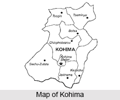
 Located at a height of 4,738 ft, Kohima is the capital city of the north eastern state of Nagaland and is known to be the second largest city in the state. This hilly city lies in the Kohima district and is one of the three Nagaland towns with Municipal council status along with Dimapur and Mokokchung.
Etymology of Kohima
Kohima is the land of the Angami Naga tribe and was originally a large village named Kewhira. The name Kohima was officially given by the British as they could not pronounce the Angami name of Kewhira. The place was named after the wild flowering plant called Kewhi, found in the mountains.
History of Kohima
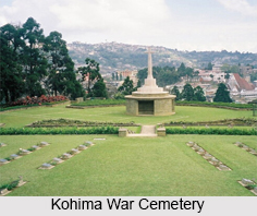
The village of Kewhira is located in the north eastern part of the present day Kohima urban area. The village is divided into four Thinuos namely, Tsutuonuomia, Lhisemia, Dapfutsumia and Pfuchatsumia. They are termed shortly as T, L, D, and P Khel respectively. Historical records states that Kohima was the point of the farthest Japanese advance into British India during Second World War. Much of the town was held briefly by Japanese troops in 1944, until the area was retaken by the British. Kohima was largely devastated by the fighting but was subsequently rebuilt. Kohima officially became the capital after the state of Nagaland was inaugurated in 1963. It is also the site of the Kohima War Cemetery and the Nagaland University.
 Administration of Kohima
The Kohima Municipal Council (KMC) was established in 2005 under the Indian Constitution 74th Amendment Act of 1992. The Greater Kohima Planning Area (GKPA) comprises the KMC plus Kohima, Meriema, Tsiesema and Thizama villages and their peripheral, cultivable and conservation areas and the "Capital Complex Area". The total area of the GKPA is 63.36 sq km, of which municipal council`s 11 sq km accounts for just over 17 percent.
Climate of Kohima
Kohima experiences a sub tropical highland climate with greater contrast between summer and winter than in other continents due to the monsoons and mild temperatures even for latitude and altitude. The coldest months are from December to February, when frost occurs and in the higher altitudes snowfall happens occasionally. The months of June to August are the hottest when the temperature ranges an average of 27 to 32 degree Celsius. Heavy rainfall occurs during summer.
Demographics of Kohima
As per the Census India reports of 2011, Kohima had a total population of 99,039 of which males and females were 51,626 and 47,413 respectively. Hence, it is known to be the second largest city in the state. Kohima has an average literacy rate of 90.76 percent, higher than the national average of 79.55 percent. The city"s population is composed of 16 tribes of Nagaland. The population of the Angamis and Lotha are the largest in current day Kohima urban area. The major religion in Kohima is Christianity which is practised by 80 percent of the population. Some of the other religions practised in the city are Hinduism, Islam and Buddhism.
Tourism in Kohima
The hilly city of Kohima is a place of attraction in the state of Nagaland. The Dzukou Valley is one of the lesser known places of attraction. Rivulets, flowers, herbs and shrubs constitute the vibrancy of this valley and offer some of the best trekking circuits in the country. Some of the other places of attraction include the Jotsoma Conserved Forest Area, the Puliebadze Wildlife Sanctuary, the Khonoma Green Village, the Japfu Peak and the Kohima War Cemetery.
Other than the various places to tour, the Hornbill Festival in Kohima is also a major facilitator of tourism in the state. Organized by the State Tourism and Art and Culture Departments, Hornbill Festival showcases cultural displays under one roof. The festival is held at Kisama Heritage Village. Kisama is about 12 km from Kohima and the festival takes place between 1st and 10th December every year.
Visiting Information on Kohima
The Dimapur Airport is the nearest at a distance of 74 km and by roadways, Kohima is connected with National Highways 2 and 29 passing through the city. The city lacks rail connectivity and the closest railway station is at Dimapur.
