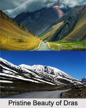
 Dras, 60 km west of Kargil on the road to Srinagar is a small township lying in the centre of the valley of the same name. It has become famous as the second coldest inhabited place in the world by virtue of the intense cold that descends upon the valley along with repeated snowfalls during winters. Winter temperature is sometimes known to plummet to less than minus 40 degrees. During the spring and summer, however, the valley around the township becomes very astonishing as the gently undulating hillsides turn into lush green pastures splashed with a variety of fragrant wild flowers. The town is often called "The Gateway to Ladakh". The official name of this town is "Drass".
The Dras valley starts from the base of the Zoji La pass, the Himalayan gateway to Ladakh. For centuries, its inhabitants are known to have negotiated this formidable pass even during the most risky period in the late autumn or early spring, when the whole sector remains snow-bound and is subject to frequent snow storms, to transport trader`s merchandise across and to help stranded travelers to traverse it. By virtue of their mastery over the pass they had established a monopoly over the carrying trade during the heydays of the Pan-Asian trade. The inhabitants of Dras can well be described as the guardian`s of Ladakh`s gateway.
History of Dras
In the royal territory of Jammu and Kashmir, Dras was a part of the Kargil tehsil of the Ladakh wazarat. Amid the intrusion by Pakistan in 1947-48, the invigorated Gilgit Scouts, having headed towards Pakistan, assaulted the Kargil region on 10th May 1948. The Indian armed force, which was accountable for the protection of Kashmir, sent reinforcements. In any case, they could not achieve Dras in time and Dras fell to the Gilgitis on 6th June 1948. Kargil and Skardu additionally fell in short order as well. In November 1948, the Indian Army launched Operation Bison, powered by tanks, and retook Dras and Kargil. Skardu stayed under the control of Pakistan. The 1949 ceasefire line runs 12 km north of Dras through Point 5353.
 The ceasefire line was renamed the Line of Control in the 1972 Shimla Agreement, by which India and Pakistan agreed to regard the line without bias to their stated positions. However, in the early months of 1999, Pakistani officers, taking on the appearance of mujahideen, penetrated into the territory and took control of the pinnacles overlooking Dras and the highway, specifically Tololing, 4 km from Dras, and Tiger Hill, 8 km from Dras. They directed cannons fire at Dras and the highway, prompting the Kargil War. The Indian armed force cleared the Tololing and Tiger Hill peaks by July 1999 and Pakistan, under American influence, accepted to pull back from the rest of the pinnacles.
The Inhabitants of Dras
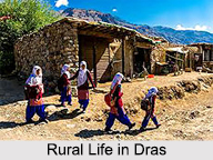
The inhabitants of Dras are mainly of the Dard race, an Aryan race believed to have originally migrated to the high valleys of the Western Himalayas from the Central Asian steppes. They speak Shina which, unlike the Tibetan-originated Ladakhi dialects spoken elsewhere in Ladakh region, belongs to the Indo-European linguistic family. Their ancestral sport, `horse-polo` which the Dards play with particular zeal, resembles the modern polo.
Dras as a base for Trekkers to Suru Valley
Drass is a convenient base for a 3-day long trek to the Suru valley across the sub-range separating the two valleys. This trek passes through some of the most beautiful upland villages and flower sprinkled meadows on both sides of the 4500 meters high Umbala pass, which falls en route. The trek to the holy cave of Amarnath in neighboring Kashmir, which starts from Minamarg below Zoji La pass, takes 3 days and involves crossing a 5200 meters high pass. Dras also offers numerous shorter treks and hikes to the upland villages.
Importance of Dras to visit Ladakh
All Tourists to Ladakh traveling from Srinagar by road are required to register themselves at the Tourist Registration Centre at Dras.
