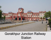
 North Eastern Railway Zone of India, often abbreviated as NER, is a part of the Indian Railways. This Indian railway zone is headquartered at Gorakhpur, Uttar Pradesh. Presently, North Eastern Railway has Lucknow NER Division, Varanasi Division and Izzatnagar Division under it. The railway is spread over 3,402.46 routes km and has about 493 Indian railway stations under it like Gorakhpur Junction Railway Station. North Eastern Railway mainly serves Uttar Pradesh, western districts of Bihar and Uttarkhand. Several tourist spots are connected by the trains of North Eastern Railway. Some of these tourist hubs of north India are Sarnath, Varanasi, Allahabad, Dudhwa, Kushinagar, Nainital, Kausani and Ranikhet. Different workshops of North Eastern Railway concentrate on actions like Vacuum Pressure Impregnation Plants and ART Conversion.
History of North Eastern Railway Zone of India
North Eastern Railway Zone of India was formed when two railways systems were amalgamated on 14th of April, 1952. They were the Oudh and Tirhut Railway and Assam Railway and the Cawnpore-Achnera Provincial State Railway of Bombay and Baroda and Central India Railway. North Eastern Railway initially comprised of 5 divisions. It was divided on 15th of January 1958, thus creating the Northeast Frontier Railway Zone. All the railway lines east of Katihar, came under the control of Northeast Frontier Railway. It was post reorganization of railway zones in 2002 that the North Eastern Railway was left with 3 divisions.
Development of North Eastern Railway Zone of India
Development of North Eastern Railway Zone of India relates to the introduction and usage of new technology for the comfort of the passengers. The railway found that technologically upgrading itself was a very motivating challenge, with the renaissance in economy. The railway aimed to grow and is tuning itself to the changes in the socio-economic scenario of the nation.
The railway inaugurated computerized passenger reservation system in 1986. Other facilities provided include Recorded Coach Guidance Display System, Automatic Teller Machines (ATM), Electronic Display Systems in stations, Interactive Voice Response Systems (IVRS), Self Dial Telephone Reservation Enquiry Booths (I ASK), Reservation Availability Position Information Display (RAPID) and Currency Exchange facilities. Introduction of the Unreserved Ticketing System (UTS) is considered to be one of the major achievements of the North Eastern Railway. Important stations under the command of North Eastern Railway have installed computerized Self Printing Ticket Machines to reduce the occurrence of long queues. This facility has greatly helped the unreserved travelers to get platform tickets. North Eastern Railway has started a system of working simultaneously on several sites for successful completion of projects. North Eastern Railway is outfitted with the largest Route Relay Interlocking (RRI) systems in the entire world. Workshops of the railway have tried to produce several signaling gears. The railway has been successful in erecting many footbridges in the same traffic block at the same time.


