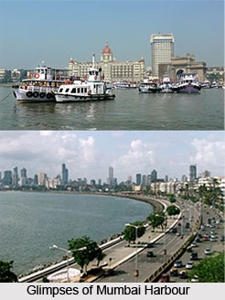
 Mumbai Harbour, also known as the Front Bay, is the southern portion of the Ulhas River estuary. The northern and narrower part of this Ulhas River estuary is called Thane Creek. The historical island of Elephanta is one of the six islands lying in the harbour. Jawaharlal Nehru Port and Navi Mumbai lie in the direction of east on the mainland, and the city of Mumbai lies to the west on Salsette Island. The Mumbai Harbour opens to the Arabian Sea to the south. The Gateway of India with its quay for Elephanta is the most visited tourist destination, followed by the INS Vikrant maritime Museum.
Historical Significance of Mumbai Harbour
The Mumbai Harbour has been the gateway since the British era and had established their factory in Mumbai. Over the years, it is one of the significant reasons for the expansion of trade and commerce in Mumbai. In 1736, Lovji Nusserwanjee Wadia propounded the Wadia shipbuilding dynasty when he attained a contract from the British East India Company for constructing docks and ships in Bombay. The Wadias at Mumbai built the first dry dock in Asia in 1750. By the 1840s the Wadia family had built more than a hundred warships for the British and had trading networks all across the world. Mumbai is a natural harbour with three enclosed wet docks, namely Indira Docks, Prince`s Docks and Victoria Docks.
Crude and petroleum products are gathered from four jetties at Jawahar Dweep, which is an island in the Mumbai Harbour and chemicals are managed from Pirpau. It can be noted that the port has existed for more than 130 years. The Bombay Port Trust, now known as Mumbai Port Trust, which was founded by the great ship builder Jamshedji Wadia in 1872, manages the Mumbai Port.
Islands of Mumbai Harbour
It is home to six islands namely Butcher Island, Cross Island, Gharapuri Island, Middle Ground, Oyster Rock and Salsette Island.
Butcher Island- Butcher Island is also known as Jawahar Dweep. It is used as an oil terminal by the Mumbai Port and is restricted to port employees.
Cross Island- It is a small island nestled just off the coast of the Dockyard Road.
Gharapuri Island- It is also known as Elephanta Island. Gharapuri Island is the best known of the islands in Mumbai Harbor. It is popular for housing the Elephanta Caves.
Middle Ground-It is a small island in the Thane creek.
Oyster Rock- It is a small group of rock outcroppings in the harbour.
Salsette Island- It is the largest island on which the cities of Mumbai and Thane are nestled.
Ecology of Mumbai Harbour
Mangrove swamps are fenced all along the northwestern and eastern shores of the Mumbai Harbour and provides an exquisite habitat for wildlife, including thousands of migratory birds such as flamingoes.


