Home > Indian History > Geography of India > Panchaganga River
Panchaganga River
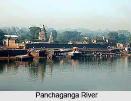
Panchaganga River flows through the outer limits of Kolhapur. It is a holy river originating from Prayag Sangam.

Share this Article:

Panchaganga River, Indian RiverPanchaganga is an ancient river and a tributary of Krishna River. It is a holy river which emerges from the Sahyadri mountain ranges of Maharashtra. Panchaganga flows through the borders of Kolhapur.

Origin and Course of Panchaganga River
The river originates from Prayag Sangam. The birthplace of this river is called Chikhlee Taluka, a small village in the district of Kolhapur. The Five Rivers; the Kasari, the Kumbhi, the Tulsi, the Bhogawati and the Saraswati convene at the Prayag Sangam to form Panchaganga. It is the beginning of the Panchaganga river and from there the river flows 30 miles towards the east developing a wide alluvial plain in the north of Kolhapur. The river concludes into the Krishna river at Kurundvad, Maharashtra.

The valley of the Panchaganga River is very fertile and its sloping banks yield rich crops during the winter season. The river is crossed by two beautiful bridges, one near the Brahmapuri hills on the north of Kolhapur and the other a few miles east to the Pune Road. The waters of all the streams which join to form the Panchaganga are much used for growing sugarcane.

Pollution and Control of Panchaganga River
Since the last decade its pollution level is increasing fast. The pollution of Panchaganga River is due to the disposal of untreated municipal sewage from the Kolhapur town. The contaminated river water is being used for drinking and irrigation purpose by the villagers as well as the city people causing health hazards. Since there is no proper drainage system in the city, the river water gets polluted because of the waste materials being dumped into the river from various industries. However MPCB (Maharashtra Pollution Control Board) took several measures to control the damages. Also various projects are being undertaken by the govt. of Maharashtra to look after the severe issue of the Panchaganga river pollution.

Religious significance of Panchaganga River
The confluence of the five river streams is known as the Prayag Sangam. Thus the Panchaganga River has much local sanctity, being like the Allahabad Triveni Sangam. The place is also visited by large number of devotees during the winter.


Share this Article:

Related Articles

More Articles in Geography of India


Geography of Uttar Pradesh
The fourth largest State in India UP is located in the Northern part of India whose area is 2,36,286 sq Kms.
Geography of Maharashtra
Covering an area of 308,000 sq. km, Maharashtra, the third largest state in India.
Geography of Kerala
Geography of Kerala includes plains, hills, valleys and coasts. With the Arabian Sea in the west, the Western Ghats in the east and networked by several rivers, Kerala enjoys diverse geographical features.
Geography of West Bengal
The geography of West Bengal is unique with high peaks of the Himalayan range in the north, the Bay of Bengal in the south and the remaining region is covered with both plains and plateaus.
Geography of Jharkhand
Geography of Jharkhand is comprised of the rich mineral resources and the highly agricultural prospect in this state.
Geography of Sikkim
Geography of Sikkim is characterised by a vast array of magnificent hillock that extends from one corner of the state to the other.
Geography of Meghalaya
The suitable climate, highland plateaus, rivers and the flora and fauna together forms the geography of Meghalaya.
Geography of Mizoram
Mizoram is surrounded by hills, valleys, rivers, waterfalls and lakes. The hills range from 1000 meters to 2000 meters. Rivers, lakes and waterfalls also play major role in forming the land of Mizoram.
Geography of Jammu & Kashmir
Jammu and Kashmir is encompassed by valleys. Some of the dominant valleys of the state are Kashmir Valley, Tawi Valley, Chenab Valley, Poonch Valley, Sind Valley and Lidder Valley etc. Jhelum River is the only major Himalayan River which flows through the Kashmir valley. Indus, Tawi, Ravi and Chenab Rivers are the major ones flowing through the region.
Geography of Daman and Diu
Daman and Diu is situated on the west coast of India and are the smallest union territories of India.
Geography of Goa
Geography of Goa occupies a prime location along the Konkan coastal belt on the western coast of India. The state is bordered by Maharashtra in the north and Karnataka in the south. The Western Ghats in the east contribute to the flora and fauna of Goa.
Geography of Arunachal Pradesh
Geography of Arunachal Pradesh reveals that it is a hilly tract nestled in the foot of Himalayas.
Geography of Kutch
Geography of Kutch District is covering an area of 45,612 km. Kutch District is the largest district in the state of Gujarat.
Geography of Ladakh
Geography of Ladakh mainly comprises the huge Karakoram Range with long stretch of cold desert which mark the region separately from the rest of the states of Indian subcontinent. Surrounded with the mountain ranges from all corners this small region separates Indian subcontinent from rest of the Asian continent.
Geography of Rajasthan
Geography of Rajasthan defines the dry topography with arid climate of the western mountain region.
Geography of Tamil Nadu
The Indian state of Tamil Nadu is located in the Northern hemisphere in the hot zone.