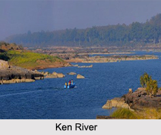
 The Ken River is one of the major rivers of the Bundelkhand region of central India and it flows through two states namely Madhya Pradesh and Uttar Pradesh. It is a tributary of the Yamuna River. An important reservoir in its upper basin impounds about 180 million cubic feet of water and irrigates about 374,000 acres in a region that is acutely liable to drought. Ken River is known for its rare Sajhar or Dendritic Agate stone. Banda city is located on banks of Ken River.
Origin of Ken River
The river originates near the village of Ahirgawan on the north-west slopes of Kaimur Range in the district of Jabalpur. It travels a distance of 427 km and then merges with the Yamuna at Chilla village, near Fatehpur in Uttar Pradesh. Out of its total length of 427 km, it flows for 292 km in Madhya Pradesh, 84 km in Uttar Pradesh, and 51 km forms the boundary between the two states. Crossing the Bijawar-Panna hills, the river cuts a 60 km long, and 150- 180 m deep gorge. It is joined by several streams in this gorge making waterfalls. Ken has an overall drainage basin of 28,058 sq. km; out of which 12,620 sq. km belong to its largest tributary, Sonar River, whose entire basin lies in Madhya Pradesh.
Tributaries of Ken River
The major tributaries of Ken River are Bawas, Dewar, Kaith, Baink, Kopra and Bearma. The Bawas, Dewar, Kaith and Baink are on its left bank and Kopra and Bearma are on its right.
Places of Interest around Ken River
There are several places of interest around this river. Amongst all, the most frequented spots are Raneh Falls and Ken Ghariyal Sanctuary. Gangau Dam, constructed at the confluence of the Ken and Simri rivers, also attracts a sizable number of tourists. Panna National Park is also situated near to this river. Then people can visit the castles which are located on the banks of Ken River. These castles were used by the Rajputs of this region to fight against the Mughals. Some of these castles make for a good trek.
Ken- Betwa River Project
The Ken-Betwa Inter Linking of River Project aims to transfer surplus water from the Ken River to the Betwa basin through concrete canal to irrigate India"s worst drought-prone Bundelkhand region. The project will benefit Uttar Pradesh and Madhya Pradesh in terms of meeting irrigation, drinking water and electricity needs of people across six districts in the two states.


