 The city of Sasaram is situated in the middle of many industries in the Rohtas district in the Shahabad region in the state of Bihar. Sasaram is known for quite a few things like the highest literacy rate, forest cover and the production of cement, fertilizer, stone chips, and also for its quarrying industry. The major languages spoken in this region are Bhojpuri, Hindi and Urdu thus showcasing the different religious communities living here like Hindus, Muslims, Sikhs, Buddhists and Jains.
Etymology of Sasaram
It is said that originally the name Sasaram was originated from the word Sahastraram. The legendary warrior of ancient India, king Sahastrabahu ruled over the area of modern day Sasaram. Sahastrabahu fought many fights and won all of them except one with Parsuram, the Brahmin warrior. The two warriors fought in this region and after the war was over the place was named by the initials of Sahastrabahu and the last of Parsuram, thus the name - Sahastra and Ram, making the name as Sahastraram. Sasaram was originally named Shah Serai, which meant Place of King as it is the birthplace of the Afghan king Sher Shah Suri.
History of Sasaram
Known to be one of the ancient cities of India, Sasaram has witnessed the legacy of Sahastrabahu, Sher Shah Suri and Jagjivan Ram Babu. In the prehistoric period, it was called the "Gateway of Vihar", which meant that it gave easy access to visit Nalanda and Gaya area. It is also known that during the Vedic period, the city of Sasaram was a part of the ancient Kashi kingdom.
Climate of Sasaram
The climate of Sasaram is warm and temperate with an average annual temperature of 26.5 degree Celsius and an average rainfall of 998 mm. The driest month is December, with 3 mm of rain. Most of the precipitation falls in July, with an average of 299 mm. The month of May is the warmest month of the year with an average temperature of 34.7 degree Celsius. In January, the average temperature is 17.3 degree Celsius and is known to have the lowest average temperature of the whole year.
 Demographics of Sasaram
As per the reports of Census India 2011, the total population of Sasaram was 247, 408 but in the urban agglomeration of Sasaram metropolitan area has about 8 lakhs people. Males constitute 52 percent of the population and females 48 percent. Sasaram has an average literacy rate of 80.26 percent, higher than the national average of 74 percent; the male literacy is 85 percent, and female literacy is 75 percent. In Sasaram, children between the ages of 0 to 6 years are about 13 percent of the population.
Places of Interest in Sasaram
The city of Sasaram is famous for its historical significance. Listed below are some of the places of interest in Sasaram which are historically significant and are also popular tourist attractions of the city.
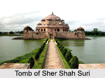
Tomb of Sher Shah Suri: Built towards the middle of the 16th century, Sher Shah Suri"s 122 ft red sandstone tomb is one of the noblest specimens of Indo-Afghan architecture in India. It stands in the middle of an artificial lake at Sasaram and the style of architecture is reminiscent of the Lodhi style. The massive free standing dome also has an aesthetic aspect of the Buddhist stupa style of the Mauryan period. Its height from the floor to the apex of the dome is 101 feet and its total height above the water is over 150 feet and is known to be the second largest dome of India. The tomb of Hasan Khan Suri, father of Sher Shah is also located in the town and is known as Sukha Roza.
Rohatsgarh Fort: Known to be one of the largest and strongest hill forts in India, this fort has a history dating back to the 7th century AD. The Rohatsgarh Fort is basically the remains of Sher Shah Suri"s Rohtas Fort and was used to serve as a safety shelter for treasures as well as families of Shah Jahan, Maan Singh, Mir Qasim, and Sher Shah Suri. It was considered, that this fort used to have 84 passages to the hill along with 14 main gate entries, 10 of which were later closed by Sher Shah Suri.
Minor Rock Edict of Ashoka: Other than the temples, tomb and forts, Sasaram is also famous for one of the 13 Minor Rock Edicts of Ashoka. The edict is situated in a small cave near the top of the terminal spur of the Kaimur Range near Sasaram.
 Rock-Cut Cave: Close to the top of the Chandan Shaheed Hill is a small rock-cut cave locally known as Chirag-dan. This rock cut cave is presumed to be an Ashokan cave with Mauryan polish in its interior. Inside the cave, on a small rocky boulder, is an inscription consisting of 8 lines written in archaic Brahmi characters.
Maa Tara Chandi Temple: Situated at a distance of merely a kilometre from the Chandan Shaheed Hill, the Maa Tara Chadi Temple is a Hindu temple dedicated to another incarnation of Goddess Durga, Maa Tara Chandi. This temple is one of the 25 Shakti Peetha. Tourists throng to this temple especially during the joyous festivals of Navaratri and Maha Shivaratri.
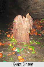
Gupt Mahadev Temple: Also known as the Gupt Dham, this cave temple is one of the most ancient temples of India. Situated atop the Kaimur Range, the cave temple is dedicated to Lord Shiva and inside this limestone cave is the Shiva Lingam, which has been present since time immemorial.
Waterfalls of Sasaram: Situated on the Kaimur Hill about 10 km from the city of Sasaram, the waterfalls of Manjhar and Dhuan are popular among the tourists. Other than its scenic beauty, these two waterfalls have been utilised as a source of hydroelectricity with the capacity to generate 50 to 100 MW of electricity.
Visiting Information on Sasaram
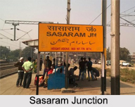
Sasaram is well connected both by road and railways and the National Highway 19 passes through the city. The city of Sasaram has its own railway junction which is situated at the centre of the city on the Grand Trunk Road. The railway route through Sasaram is the Grand Chord line of Indian Railways, connecting Kolkata and New Delhi, and has 3 more railway tracks running in parallel. The city also has a small, old airport called the Suara Airport.
