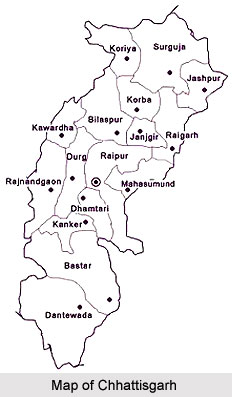
 Chhattisgarh is a young state that acquired its state hood recently. It is the tenth largest state of India. It is one of the important states that produce electric power and steel. 15% of steel is produced by the state. Chhattisgarh is bordered by the state of Madhya Pradesh in the North West, Maharashtra on the west, Andhra Pradesh on the south, Jharkhand in the north east, Orissa in the east and Uttar Pradesh in the north.
History of Chattisgarh
The name "Chhattisgarh" finds mention even in the Indian Epics, Ramayana and Mahabharata. It is not mentioned as Chhattisgarh but in its old name Dakshin-Kausal. The temples of Dakshin-Kausal are famous to the tourists. According to the mythological legends, Rama, during his Vanvas stayed in Dakshin Kosala.
In 1741, the Maratha Empire attacked Chhattisgarh and ruled for many years. After four years they deposed Raghunathsinghji, the last surviving member of the Ratanpur house.
In 1758, the Marathas annexed Chhattisgarh. The Maratha rule was a period of anarchy. They openly surrendered the interests of the region to the British. The Gond tribe challenged the advances of the Marathas and this led to conflicts between the Marathas and Gonds. In the beginning of the Nineteenth Century the Pindaris attacked this region.
In 1818 Chhattisgarh for the first time came under British control. In 1854, when the province of Nagpur lapsed to the British government, Chhattisgarh was formed into a deputy commissionership with its headquarters at Raipur. The British made changes in the administrative and revenue systems of Chhattisgarh, which affected the people of Chhattisgarh. The British were resisted by the tribes which lasted nearly five years. In 1857, the Sepoy Mutiny was organized by Vir Narain Singh who was a Jamindar of Sonakhan. He formed an army of 500 men to crush the British. He was later arrested and was hanged on the 10th December, 1857. He became the first martyr from Chhattisgarh. The people of Chhatisgarh remember him with pride.
 In 1904 Sambalpur district was relocated to Orissa and estates of Surguja were shifted from Bengal to Chhattisgarh. Chhattisgarh was carved out of Madhya Pradesh and came into existence on 1 November 2000.
There is an interesting story explaining the origin of the name of Chhattisgarh. According to the British Chronicler, J.B. Beglar, "the real name is Chhattisghar and not Chhatisgarh". According to tradition, ages ago during the time of Jarasandha, thirty-six families of Dalits emigrated southwards from Jarasandha`s kingdom and established themselves in country, which after them is called Chhattisgarh.
Another common explanation regarding the origins of the name Chhatisgarh is that it denotes the number of forts or garhs in the region, which are supposed to be thirty-six in number. Therefore the meaning of Chhattisgarh is thirty-six forts. Anyhow experts do not agree with this explanation, as they say that Chhatisgarh do not contain thirty-six forts. Chhattisgarh is the corrupted form of `Chedisgarh` or the political seat of the Chedis.
Geography of Chhattisgarh
Chhattisgarh covers an area of 1, 35,133 sq. kms. The northern side of Chhattisgarh lies on the edge of the Indo-Gangetic plain. The eastern end of the Satpura mountain Range and the western edge of the Chota Nagpur Plateau divide the Mahanadi River basin from the Indo-Gangetic plain. The middle potion of the place lies in the upper basin of the Mahanadi. The northern and southern parts of the state are hilly, while the central part is a fertile plain. It lies in the watershed of Godavari River. Its tributary is Indravati River. The chief river is Maahandi. Other rivers of the state are Hasdo, Rihand, Indravati, Jonk and Arpa.
Demography of Chhattisgarh
The population of Chhattisgarh is 47, 06,393 according to the population census of 2011. The proportion of women is second highest among states in India. The religious sects found here are like Satnami, Kabirpanth, and Ramnami Samaj which originated as reaction to caste-based Hinduism practised by people coming to the state. The languages used by the people here are Chhatisgarhi, tribal dialects and Hindi. Literacy rate in Chhattisgarh is 70.28 percent according to 2011 census. The state also won the National Literacy Award in 2013.
Culture of Chattisgarh
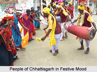
 Chattisgarh is known for "Kosa silk" and "lost wax art". Besides sarees and salwar suits, the fabric is used to create lehengas, stoles, shawls and menswear including jackets, shirts, achkans and sherwanis. Chattisgarh is famous for art and sculpture. International sculptor, Sushil Sakhuja`s Dhokra Nandi is famous in India. Panthi, Rawat Nacha, Karma, Pandwani, Chaitra, Kaksar, Saila and Soowa are the several Chattisgarhi tribal dance styles of Chhattisgarh.
Education of Chhattisgarh
The medium of instruction in the state from elementary schools to degree colleges is Hindi. The two recognised universities of Chhattisgarh are Guru Ghasidas University, Bilaspur and Pandit Ravishankar Shukla University, Raipur.
Administration of Chhattisgarh
The first chief minister of Chhattisgarh was Ajit Jogi. The major political parties of the state are Bharatiya Janata Party, Indian National Congress, Bahujan Samaj Party.
The Bharatiya Janata Party is at present holding the majority in the Legislative Assembly of Chhattisgarh. The present chief minister of the state is Raman Singh. The governor is Shekhar Dutt. The state has twenty seven districts.
Economy of Chhattisgarh
About 45% of Chhattisgarh is under forests. The main crops grown here are paddy, wheat, maize, groundnut, pulses and oilseeds. Chhattisgarh is a state rich in mineral resources as Iron-ore, limestone, dolomite, coal, and bauxite. It is the only state in the country producing tin-ore. Other minerals found in the state are Korandum, garnet, quartz, marble and diamond. The state`s economy is fuelled by the presence of the Bhilai Steel Plant, S.E.C.Railway Zone, BALCO Aluminium Plant, and NTPC Korba and S.E.C.L. There are eight sponge iron plants in the private sector, 13 Ferro-alloy plants, 125 steel rolling mills and one H.R. strip plant. There are nine major cement plants. There are also iron casting units, engineering and fabrication units, agro-based food processing, chemical and plastic industries have been established.
The irrigation potential of the state is 13.39 lakhs. The important irrigation projects are Ravishankar Sagar Mahanadi Project, Hasdeo-Bango, Kodar, Jonk, Pairi and Arpa. About 90% of the villages are electrified.
Tourism in Chhattisgarh
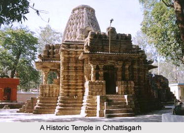
Chhattisgarh is full of ancient monuments, rare wildlife, exquisitely carved temples, Buddhist sites, palaces, water falls, caves, rock paintings and hill plateaus. Most of these sites are untouched and unexplored. The green state of Chhattisgarh has 41.33% of its area under forests and is one of the richest bio-diversity areas in the country.
Beautiful waterfalls in Chhattisgarh are Akuri Nala and Amrit Dhara waterfalls, Tiger point waterfall at Mainpat in Sarguja district, Ramdaha waterfall in Korea district, Gavar Ghat waterfall, and Chitrakot and Tirathgarh waterfalls in Bastar district.
The major hot spring Known as Taat Pani, flows in Sarguja district. This hot spring flows throughout the year. It is reputed to have medicinal properties. Achanakmar Wildlife Sanctuary in Bilaspur district, Gamarda Reserve forest at Sarangarh in Raigarh district, Indravati National Park and Kanger valley national park in Bastar district and Barnawapara Wildlife Sanctuary in Mahasamund district are good places for eco-tourism. There are some archaeological locations like Barsoor in Dantewada district, Sirpur in Mahasamund district and Surguja in Surguja district, Ratanpur in Bilaspur district, and Malhar. Out of these there are many archaeological sites and natural forests found in this region


