The importance of Kaveri River as most scared is also sanctioned by the fact that the pilgrims perform a holy pilgrimage of a parikrama or circumambulation of the river. The Kaveri Parikrama is considered to be a praiseworthy act that a pilgrim can undertake. Many sadhus and pilgrims walk on foot from the Arabian Sea at Bharuch, in Gujarat, along the river, to the source of the river in Maikal Mountains or Amarkantak hills in Madhya Pradesh. Places of historical Interest in the valley of river Kaveri are Joga Ka Quilla, Chhatri of Baji Rao Peshwa and Bhimbetka, Dugdhdhara, Dhardi falls, Bheraghat, Dhuandhara, Kapiladhara and Sahastradhara.
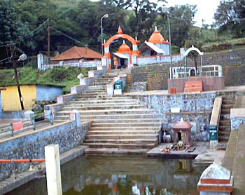 Talakaveri is the well-known pilgrimage site set amidst Bramahagiri Hills in Kodagu. Thousands of pilgrims come to the three temples at the source of the river, particularly on the specified day known as Tula sankramana when the river water has been said to gush out like a fountain at a predetermined time. During the month of Tula, devotees take holy dip (tula snanam) in the Kaveri at the pilgrim centers in its banks across Tamilnadu, most prominent of them is the Mayavaram. The three major river islands at Kaveri have a Sri Vaishnava heritage, with many sculptures of Lord Vishnu in a reclining posture on the legendary seven-headed serpent (Sesha) as his celestial bed or Sheshashayana. These three temples are the Adi Ranga, Madya Ranga, and Anthya Ranga.
Some high-rise temples are built by the Chola kings, then maintained and nourished by the Vijayanagara and Maratha kings, these are spread across the Kaveri delta. Majority of the Vaishnava Divya desam temples and Saivite `Paadal Petra sthalam` temples are in the delta too. The temple town of Kumbakonam lies in the Kaveri banks. The bathing ghats include Amma Mandapam, Bhagavath Padithurai, Chakkarai Padithurai, Pushya Mandapa Padithurai and Thula Kattam in Mayavaram.


