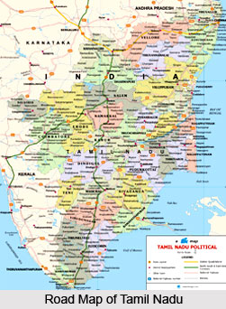
 The Indian state of Tamil Nadu is located in the Northern hemisphere in the hot zone between 8° and 13° N. latitude and between 78° and 80° E. longitude. In the north, the state is surrounded by the states of Karnataka and Andhra Pradesh and Kerala is situated in the west of it.
Geographically, the southern tip of Tamil Nadu is in the Indian Ocean and the long eastern coast is encircled by the Bay of Bengal. The easternmost tip is formed by the Point Calimere and the Mudumalai wildlife sanctuary is the westernmost tip. The Pulicat Lake is situated in the northern extreme. The southernmost tip of Tamil Nadu is the Cape Comorin or Kanyakumari.
Tamil Nadu is the eleventh largest state in India. The population of the state has crossed over 6 crores and occupies an area of 130,058 sq. kms. Within the boundaries of Tamil Nadu, the union territory of Pondicherry is a tiny pocket near Cuddalore district; Karaikal. The ancient Tamils divided Tamil Nadu into five major physiographic parts. These five parts include the Kurinji mountainous region, Mullai forest region, Marudham fertile plains, Neidhal coastal region and Palai arid region.
In the Nilgiris of Tamil Nadu, the Western Ghats and the Eastern Ghats meet. Tamil Nadu contains various hill stations called Ooty, Kodaikanal, Kothagiri and Yercaud. Now, the Eastern Ghats is almost broken and appears to be a remaining mountain. But, the Western Ghats stretches along almost as an unbroken chain except for a 25 km gap at Palakkadu and a still lesser gap in Shencottah. These gaps act as the entry points to the state of Kerala.
 The Eastern Ghats does not enjoy much rainfall. But the Western Ghats of Tamil Nadu take pleasure of abundant rain and are full of evergreen forests and the valleys of Cumbum and Pollachi. Tamil Nadu also has picturesque sceneries containing tea, coffee and spice plantations. The `Shervaroys` is the term used for the upper reaches of the Eastern Ghats, which are famous for their fruit gardens and coffee plantations.
There are rich varieties of flora and fauna available in the geographical area of Tamil Nadu. The Eastern Ghats of Tamil Nadu contains Indira Gandhi wildlife sanctuary in Anaimalai and Mudumalai wildlife sanctuary of the state. The site of elephants, tigers, bisons and a variety of monkeys and deer roaming about freely in these sanctuaries is very beautiful in Tamil Nadu. Here, more than 3000 plant species can be found. The Kurinji plant is the most important of them and it blooms once in 12 years. It is said the name of this hill was derived from this flower. The Palani hills and Courtallam of Tamil Nadu are full of various medicinal herbs. The major cottage industries of Tamil Nadu are situated in Tirunelveli district. The Palmyrah groves are also found in abundance here.
The geographical structure of Kanyakumari district in Tamil Nadu is full of rubber plantations and sandal trees. These are grown in Jawadu hills of the Eastern Ghats near Vellore. There is hardly any permanent river in Tamil Nadu often a sandy dry river bed can be seen in summer.
The longest and the most important river of Tamil Nadu is the Cauvery River. The people of the deltaic region of Thanjavur and Nagapattinam districts use the water of this river for cultivation process. Some other rivers of Tamil Nadu are the Palar, Pennar, Vaigai, Tamiraparani, which are flooded during the rainy season. The only barren region or Palai of Tamil Nadu is found in Tirunelveli district. Tamil Nadu has a long coastal line, about 912 km which is called `coromandal coast` or `cholamandalak karai` in the northern half and the southern coast is the pearl fisheries coast. The ancient seaports along the coromandal coast of Tamil Nadu are Mylapore, Poompuhar, Mamallapuram and Kayalpattinam. The Mangrove forests found at Pichavaram near Chidambaram, Pulicat Lake and Vedanthangal of Tamil Nadu are important bird sanctuaries.
The climate is tropical and there is little difference between the summer and winter as Tamil Nadu falls in the Torrid Zone. The temperature here rises above 40° C during the hottest months of April, May and June. The climate here is due to its geographical location, which is situated near the coastal regions. The warm and humid climate makes everyone sweating during summer. But the sea breeze makes the evenings and nights cooler. During the month from December and February, a mild winter can be enjoyed.


