Home > Indian History > Geography of India > Altitudinal Zones of Vegetation in Mountainous Regions of India
Altitudinal Zones of Vegetation in Mountainous Regions of India
Altitudes vary at almost every angle in the Himalayan regions, the vegetation abruptly metamorphosing.

Share this Article:

Altitudinal Zones of Vegetation in Mountainous Regions of IndiaAltitude is a vital condition in the circulation of vegetation in mountainous region, because temperature decreases with increasing altitude. In mountainous regions one can notice a series of natural vegetation belts from tropical to the tundra region. All of them are condensed within an altitude of six kilometres or so. However, even in the same altitude, sunny areas vary in plant life from those that are not so sunny.

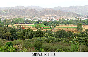
Shivaliks, foothills of the Himalayas, are beautified with tropical moist deciduous forests. Sal is the most prevailing and economically essential species. Bamboo trees are also familiar within this belt.

It is then followed by wet hill forests, within 1,000 and 2,000 metres above sea level. Evergreen wide leave oaks, chestnuts and apples are the regular trees. Other trees that can be found are ash and beech. At such an altitude in north-eastern hills where it rains profoundly, one can witness the presence of sub-tropical pine forests, in which chir or chil trees dominate.

Further up i.e. within 1,600 and 3,300 metres above sea level, pine, cedar, silver fir and spruce are some of the more significant species. These are the well-known coniferous forests of the temperate region. In the inner Himalayan ranges and in drier climates these trees along with deodar can be found in abundance.

Temperate coniferous forests give way to Alpine forests, mostly at 3,600 metres above sea level. They consist of silver firs, pines, birches and junipers. Alpine forests yield territory to Alpine grasslands, through shrubs and scrub.


Share this Article:

Related Articles

More Articles in Geography of India


Geography of Uttar Pradesh
The fourth largest State in India UP is located in the Northern part of India whose area is 2,36,286 sq Kms.
Geography of Maharashtra
Covering an area of 308,000 sq. km, Maharashtra, the third largest state in India.
Geography of Kerala
Geography of Kerala includes plains, hills, valleys and coasts. With the Arabian Sea in the west, the Western Ghats in the east and networked by several rivers, Kerala enjoys diverse geographical features.
Geography of West Bengal
The geography of West Bengal is unique with high peaks of the Himalayan range in the north, the Bay of Bengal in the south and the remaining region is covered with both plains and plateaus.
Geography of Jharkhand
Geography of Jharkhand is comprised of the rich mineral resources and the highly agricultural prospect in this state.
Geography of Sikkim
Geography of Sikkim is characterised by a vast array of magnificent hillock that extends from one corner of the state to the other.
Geography of Meghalaya
The suitable climate, highland plateaus, rivers and the flora and fauna together forms the geography of Meghalaya.
Geography of Mizoram
Mizoram is surrounded by hills, valleys, rivers, waterfalls and lakes. The hills range from 1000 meters to 2000 meters. Rivers, lakes and waterfalls also play major role in forming the land of Mizoram.
Geography of Jammu & Kashmir
Jammu and Kashmir is encompassed by valleys. Some of the dominant valleys of the state are Kashmir Valley, Tawi Valley, Chenab Valley, Poonch Valley, Sind Valley and Lidder Valley etc. Jhelum River is the only major Himalayan River which flows through the Kashmir valley. Indus, Tawi, Ravi and Chenab Rivers are the major ones flowing through the region.
Geography of Daman and Diu
Daman and Diu is situated on the west coast of India and are the smallest union territories of India.
Geography of Goa
Geography of Goa occupies a prime location along the Konkan coastal belt on the western coast of India. The state is bordered by Maharashtra in the north and Karnataka in the south. The Western Ghats in the east contribute to the flora and fauna of Goa.
Geography of Arunachal Pradesh
Geography of Arunachal Pradesh reveals that it is a hilly tract nestled in the foot of Himalayas.
Geography of Kutch
Geography of Kutch District is covering an area of 45,612 km. Kutch District is the largest district in the state of Gujarat.
Geography of Ladakh
Geography of Ladakh mainly comprises the huge Karakoram Range with long stretch of cold desert which mark the region separately from the rest of the states of Indian subcontinent. Surrounded with the mountain ranges from all corners this small region separates Indian subcontinent from rest of the Asian continent.
Geography of Rajasthan
Geography of Rajasthan defines the dry topography with arid climate of the western mountain region.
Geography of Tamil Nadu
The Indian state of Tamil Nadu is located in the Northern hemisphere in the hot zone.