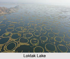
 Known to be the largest freshwater lake in the north eastern India, the Loktak Lake is located in Moirang in the state of Manipur. The Loktak Lake is famous for the phumdis, which is a collection of heterogeneous mass of vegetation, soil and organic matter at various stages of decomposition. Resembling miniature islands, these phumdis are found in different forms, floating on the lake.
The Loktak Lake also serves as a source of water for hydropower generation, irrigation and drinking water supply in the region, other than being the source of income for many fishermen who largely depend on it.
Etymology of Loktak Lake
The word Loktak is of Meitei origin and is a combination of two words, "Lok" meaning stream and "Tak" meaning the end.
Geography of Loktak Lake
The Loktak Lake has a total surface area of 287 sq. km and a catchment area of 980 sq. km, out of which parts of it are under habitation, paddy cultivation and forest cover. At the southern part of the Imphal Valley, the Loktak Lake comprises of large pockets of open water and marshy land. The origin of the Manipur river system and its tributaries, which flows in a north- south direction and drains into the Loktak Lake, is from the hill ranges immediately to the west of the lake. The lake is further divided into 2 zones, namely the "Core Zone" or the protected no development zone that covers an area of 70 sq. km and the remaining area is the "Buffer Zone".
Zones of Loktak Lake
Based on the biodiversity and the pressure of human activities, the Loktak Lake is broadly divided into the northern, central and southern zones. The northern zone extends from the eastern side of the Nambol River to Phabakchao including Maibam Phumlak and has four main streams or rivers. These are namely the Manipur River, Yangoi River, Nambol River and Thongjaorok flowing into the lake. The phumdis in the northern zone are burnt annually during the months of January and March for construction of fish cum paddy farms.
The central zone extends from the western part of the Nambol River to Laphu Pat and encloses prominent islands of Thanga, Karang and Ithing. The central zone is the main open water zone of the Loktak Lake and was once relatively free of phumdis in the past. But in the recent years, artificially created phumdis or athaphums were constructed by the local villagers for fishing. The State Fisheries Department has established a fisheries centre within this zone at Takmu pat for fisheries development.
Linked with the Khuga River by the Ungamel channel, the southern zone of the Loktak Lake encompasses the Keibul Lamjao National Park, which is the only floating national park in the world. The park is the last natural refuge of the endangered Sangai, the state animal.
Biodiversity of Lokatak Lake
Biologically diverse, the Loktak Lake comprises of 233 species of aquatic plants, 57 species of water- birds and another 14 species of wetland associated birds that have been noted in the lake including 28 species of migratory waterfowl. Other than these, there are also 425 species of animals including rare animals like the sambhar, barking deer, Indian python, Sangai, etc.
Pollution of Loktak Lake
The Loktak Lake has faced serious problems due to loss of vegetal cover in the catchment area and construction of Ithai barrage at the outlet of the lake for multipurpose development of water resources. The degradation of the catchment area has led to the problems of siltation. The sediments deposit at the mouth of the rivers contributes to shallow lake bottom. The domestic sewage from Imphal city carried by Nambul River is discharged into the lake affecting its water quality, thus leading to eutrophication.
Visiting Information on Loktak Lake
The Imphal Airport is the closest at a distance of 44 km from the lake and by roadways, the capital city of Imphal is the nearest at a distance of about 39 km from the Loktak Lake.


