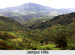
 Jampui hill which is also referred to as `the seat of permanent spring` is the highest hill range in the Northeast state of Tripura. Jampui hill is an amalgamation of luxuriant landscape, flourishing forests and beautiful orange gardens. Jampui is also popular for its pleasant landscape and bracing climate. Throughout the year, its serene and eco-friendly ambience attracts numerous tourists from various corners of the world.
Location of Jampui Hills
Jampui is located in North Tripura district in the Tripura state of India. These hills exactly lie in the north eastern part of Tripura bordering Mizoram in the east. The average altitude of the hill range is around 1000 metres from sea level. The entire Jampui hills fall within Kanchanpur sub-division under North Tripura district. It is situated about 200 km away from Agartala.
Villages of Jampui Hills
Jampui hills shelter around ten small villages namely Vaisam, Hmawngchuan, Hmunpui, Tlaksih, Vanghmun, Behliangchhip, Bangla Zion, Tlangsang, Sabual and Phuldungsei. Vanghmun is the headquarters of Jampui R.D Block. Most of the habitants of these villages are the Mizo community.
Attractions of Jampui Hills
 The hills are positioned in such a way that they provide stunning panoramic views of the valley and villages of Mizoram. The enchanting greenness of the Jampui hills is the result of its bracing climate; giving visitors reason enough to call them `the seat of permanent spring`. By climbing up those gentle heights one can enjoy panoramas tinged by spectacular sunrises and sunsets. Jampui is home to some very exotic species of orchids, ornamental trees and fragrant orange groves. The abundance of oranges has in fact, given wing to the `Orange Festival` held in the month of November when the surrounding hills are heavy with the fruit and a riot of colour. The cobweb of picturesque trekking trails, punctuated by friendly brooks and serene lakes along the Jampui hills, are a treat for the outdoor enthusiast.
Connectivity of Jampui Hills
The closest railway station is at Kumarghat of NF railway. The State capital, Agartala is well connected by air with Kolkata and Guwahati. Kailashahar, the District Head quarter of North Tripura District is connected by regular Bus service with Agartala.


