 Apart from the rugged beauty of the mountains there are four hilly and forest areas in the Indian subcontinent. The first area comprises the Great Central Indian belt, which includes the Satpuras, the Vindhyas, Maikal, Chhota Nagpur and the Orissan hills. The other three hilly and forest areas are the Aravallis, the Western Ghats and the Eastern Ghats. In these hilly and forest areas many primitive tribes live who lead a wild nomadic life. They do not produce their food, but gather vegetable and animal food as well.
These five broad physical divisions of the Indian subcontinent have many physical subdivisions, which are discussed in the following paragraphs indicating the political division in which they lie.
Baluchistan: On the west side of Baluchistan there is Iran and on its north there is Afghanistan. On the East the Kirthar range separates it from Sind while on the south it has the Arabian Sea. The coast is known as the Makran coast. It is mainly a dry and mountainous region. The important rivers of this region are the Zhob and the Gomal in the north, the Bolan in the middle and the Dasht and the Kech in the south. Thus physically Baluchistan can be divided into three distinct regions namely the north, the middle and the south.
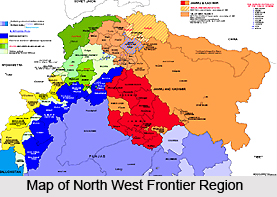
North West Frontier Region: It can be divided into four subdivisions namely Peshawar plains, Kohat and Bannu plains, the hilly region on the north east of the Peshawar plains comprising Swat, Chitral etc. and the fourth one is the upper courses of the river Indus which form its Eastern boundary.
Sindh: This region comprises the upper part of the valley of the Indus including its Eastern and Western parts, its delta and the desert region, which are an extension of the desert of Rajasthan and the foothill zone of the Kirthar Range. In this region the rainfall is low but the alluvial soil is fertile.
Punjab: It can be divided into two main sub-divisions namely Potwar plateau, which is located between the Indus and the Salt Range, and the Punjab plain that extends up to the Sutlej. The Central Punjab has often served as a highway between the Kabul valley and the plains of the Ganga-Yamuna. The southern Punjab is contained between the western mountains and the desert while the northern Punjab borders the foothills of the Himalayan ranges as well.
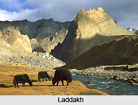
Kashmir, Laddakh and Himachal Pradesh: All these three regions fundamentally are part of the Himalayan region. Himachal Pradesh comprises the Himalayas, the Lesser Himalayas and the Siwalik foothills. So there is a great variety in its physical features. The Kashmir region consists of five sub-divisions namely (i) Poonch and Jammu (ii) Pir Panjal Range (iii) The Vale of Kashmir (iv) Main Himalayan Mass and (v) Gilgilt-Hunza region.
In the middle of this region is the vale of Kashmir while Ladakh consists mainly of the Lesser Himalayas.
 Rajasthan: The place has two natural subdivisions. The Eastern part is hilly and comparatively less dry and fertile while the Western part is mostly a desert area and is covered with scrubby stunted vegetations. The Aravalli Range forms the dividing line of these two parts.
Uttar Pradesh, Bihar, and Bengal: This region can be sub-divided into three parts. The Upper Ganga valley or the Ganga-Yamuna Doab which extends up to Allahabad, the middle Ganga valley which consists of eastern Uttar Pradesh and Bihar and extends up to Rajmahal hills and the lower Ganga valley which is mainly a delta region. The Peninsular region extends far into Uttar Pradesh, Bihar and Bengal. In the Ganga basin the rainfall increases steadily as one move from west to east rising from about 50 cm per annum in West Uttar Pradesh to 200 cm in Bengal.
Assam: The Central part of Assam comprises the valley of the Brahmaputra. The other two regions of Assam are the Himalayan frontier and the Shillong Plateau. Thus this region consists of three entirely different natural regions.
Madhya Pradesh: It is bounded by the Aravallis on the west, the Vindhyas in the south and the Ganga-Yamuna doab in the east. In the northeast there are the Malwa plateau and Bundelkhand. It has two sub-divisions. The Malwa Plateau, through which flow the Narmada and its tributaries, is a fertile region whereas Bundelkhand is comparatively dry and has a rugged surface.
Maharashtra: This region lies to the south of the Vindhyas and touches the northern boundary of the Deccan. The Upper courses of the river Godavari flow through this region. There are many sloppy plains interspersed with flat peaked hills in this region. It includes four former cultural units namely Khandesh, Western Maharashtra, Vidarbha and Korikan. It has a number of ports. It has sufficient rainfall. Today rice, wheat, millet, pulses and cotton are grown in this region, cotton being one of its major exports.
Karnataka: It is the southern part of the Deccan plateau and is a sort of triangle formed by the Krishna River and the Eastern and the Western Ghats. In the northern half of the Mysore plateau flow the Krishna and its tributaries and in the southern half there flows the Tungabhadra and the Kaveri and other rivers. The Doab formed by the Krishna and the Tungabhadra is known as Raichur Doab. The northern part of the region has the lowest rainfall in peninsular India but it becomes better watered towards the south. The chief port of this region is Goa.
Kerala: It comprises the western coastal plain, which is known as Malabar. It can be divided into two sub-regions v.i.z the Northern and the Southern. It has a fertile soil. The chief produce is rice but pulses and millets are also grown in this area. Pepper and spices are also included in the list.
Gujarat: Gujarat region consists of a low-lying plain, which is enriched by the alluvium brought down from the hills of Central India by four great rivers, the Sabarmati, the Mahi, the Narmada and the Tapti together with Cutch and Kathiawar.
Thus this region consists of three physical zones namely Gujarat, Cutch and Kathiawar. Cutch is marshy and sandy and Kathiawar is formed by Deccan lands, the rainfall in Gujarat ranges from 50 cm to over 150 cm per annum. It has a number of ports through which both coastal and external trade has passed.
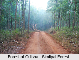
 Orissa: It consists of the deltas of two rivers namely the Mahanadi and the Vaitarni. On the north of this region are the hills of Central India. The rainfall is as high as that of Bengal. Rice is grown everywhere on the coastal plain.
Andhra: It consists of the middle and lower basins of the Godavari and Krishna rivers. It has two distinct parts namely the coastal region, which is known as Andhra, and the interior region, which is called Telingana. The rainfall of coastal Andhra is considerably lower than that of Orissa. Generally Rice, millet and pulses are grown in Andhra.
Tamil Nadu: It consists of the coastal region to the south of the Krishna River that comprises the delta of the Kaveri. The interior consists of the hills of the Eastern Ghat as well as the Western Ghat. Here the climate and crops resemble those of the most fertile and developed parts of coastal Andhra.
The people of each of the above regions in the Indian sub-continent have their own character and mode of life which have developed in the course of times as they discovered ways of making their living from the resources available in a particular region. In this sub-continent food-habits had also developed on the basis of articles of food available in a particular region but these were modified by many factors in course of time such as the fusion of the Aryans with the non-Aryans, invasions of foreigners, religious ideals and economic status of an individual in society.


