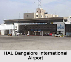
 HAL Bangalore International Airport, also known as HAL Airport or Hindustan Airport, is an airport located in the heart of Bengaluru city, in Karnataka. It is the erstwhile commercial airport that served Bengaluru for domestic and international operations. Due to the steeply rising commercial air and passenger traffic and its limited capacity, the airport was shut for commercial operations and was replaced by the newly constructed Bangalore International Airport (now Kempegowda International Airport) in Devanahalli town, 40 kilometres north-east to the city. Administered by Hindustan Aeronautics Limited (HAL), the airport is currently used for military flights, VVIP flying, test flights and chartered flights. Since its closure to commercial services in May 2008, there have been repetitive attempts to reopen the airport for commercial domestic and international flights, because of the cumulative loss incurred by HAL and the airport"s location being in closer proximity with the city.
Closure of Civil Aviation in HAL Bangalore International Airport
In the early 2000s, commercial traffic to HAL Airport was rising at a steep rate of roughly 35% every year. Between 2006 and 2007, the airport was blocked by passenger traffic of 8.2 million, much beyond its capacity of 3.6 million. This called for the construction of a new and developed airport to serve the city with domestic and international flight operations. In July 2004, the Government of India (Civil Aviation ministry) approved this by entering into a concession agreement with Bangalore International Airport Limited (formed by Switzerland`s Zurich Airport, Germany`s Siemens Project Ventures GmbH, Government of Karnataka and the Airports Authority of India), the private owner and operator of the new airport, called Kempegowda International Airport today. Like all concession agreements for green field airports, the agreement has a clause that no new or existing airport can be permitted by the government to be developed as, or improved or upgraded into, an international or domestic airport within an aerial distance of 150 kilometres of the airport before the 25th anniversary of the airport opening date. In January 2015, the Defence Minister appealed to the Civil Aviation Minister to consider reinstating commercial aviation services at the HAL Airport, citing reasons of huge revenue losses suffered by HAL as a result of its airport"s closure in 2008. Apart from the commercial reason, the Defence Minister also specified high air and passenger traffic growth and close proximity to Bengaluru city as appropriate reasons to reopen HAL Airport. However, the Government of India has repeatedly denied its reopening given the 150 kilometre radius clause which is inviolable.
The facilities at HAL Airport comprise separate check-in points for domestic and international arrivals and departures, two aerobridges, one runway oriented to 90/270 degrees, 4 taxiways and 6 aprons with more than 30 bays.


