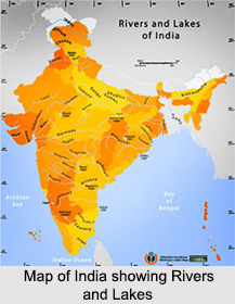
 Lakes of India are significant geographically and also serve as major tourist attractions. Such water bodies are spread across India. The lakes of India are generally categorized as fresh water and brackish water lakes. There are both natural and man made lakes to be found across the subcontinent. It is difficult to trace the history of the natural lakes of India. But the man made ones have a historical background, since most of them were built by kings and emperors as reservoirs. Lakes differ from one region to another. Like for instance, the lakes in the Himalayan region will differ from the lakes in the southern peninsula. As a result, a regional survey of the Lakes of India is easier than the study of its historical evolution. Given below are the Lakes of India.
Lakes of Northern India
Gadsar Lake is located in Ganderbal district of Kashmir Valley in Jammu and Kashmir. Characteristically, it is an alpine high altitude oligotrophic lake. Pooh sub-division of the Kinnaur district of Himachal Pradesh is beautified by Nako Lake. This lake is situated at an elevation of about 3,662 m (12,010 ft) and therefore is known as a high altitude lake. Sat Tal is a complex of 7 lakes, situated in the Lower Himalayan Range near Bhimtal, a town in the Nainital district of Uttarakhand. The lakes of Rajasthan add vitality to the colossal forts and palaces. Sambhar Salt Lake is situated about 96 km south west of the city of Jaipur in Rajasthan. It has a catchment area of about 5700 square kilometers. Some of the other Lakes of Northern India are Dal Lake, Manasbal Lake, Bhimtal Lake and Naukuchia Tal.
Lakes of Western India
Powai Lake is situated in Mumbai, Maharashtra in the Powai Valley. Venna Lake is situated in Mahabaleshwar in Maharashtra. Kankaria Lake is located in Ahmedabad in Gujarat. Hamirsar Lake is located in Bhuj town in Gujarat. Some of the other Lakes of Western India are Nakki Lake, Shakoor Lake and Moti Lake.
Lakes of Southern India
Hussain Sagar is a lake located in Hyderabad in Andhra Pradesh. It is also known as the Tank Bund. Over 96 percent of Pulicat Lake is located in Nellore in Andhra Pradesh on the Coromandal Coast. Chembarambakkam Lake is located in the district of Kanchipuram in Tamil Nadu. Characteristically, this lake is a reservoir. Bellandur Lake beautifies the suburb of Bellandur in the southeast of Bengaluru in Karnataka. Some of the other Lakes of Southern India are Veeranam Lake, Hebbal Lake and Kolleru Lake.
Lakes of Eastern India
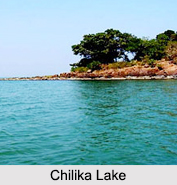
Senchal Lake is situated about 10 km south-east of the town called Darjeeling in West Bengal. It has a surface elevation of about 8,160 ft and serves as the main reservoir of potable water for the town. Rasikbil is located in the Cooch Behar district of West Bengal. Raja Talab is situated in Dhanbad in Jharkhand. Dimna Lake is situated at the foothills of Dalma Range in Jharkhand. Chilika Lake can be defined as a brackish water lagoon. It is located in Puri, Khurda and Ganjam districts of Odisha. It freezes totally during the winter season.
Anshupa Lake is situated in Cuttack district of Odisha, more specifically, on the left bank of the Mahanadi River. Some of the other Lakes of Eastern India are Topchanchi Lake, Kanjia Lake and Bhangzang Salamander Lake.
Lakes of North Eastern India
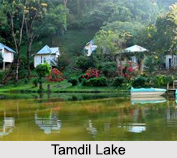
Tamdil is a lake situated in Mizoram about 110 km south-east of Aizwal town and about 7 km from Saitual village. Dipor Bil is located to the south-west of the city of Guwahati in Kamrup district in Assam. This lake has a surface area of about 4,014 ha, average depth of about 1 m, maximum depth of about 4 m and surface elevation of about 53 m. Amarsagar Lake is located in the South Tripura District in Tripura. Rudrasagar Lake is located in Melaghar in Tripura. Some of the other Lakes of North Eastern India are Dumboor Lake, Chandubi Lake, Son Beel and Pala Tipo.
Significance of Lakes of India
Lakes of India are one of the primary sources of water supply. These lakes also act as water sources for the wild species that inhabit the national parks. Several gardens and Indian wildlife sanctuaries owe their magnificence to the lakes. The Lakes of India are considered religiously significant. Most of the lakes in India are renowned for their religious importance. They are also active in encouraging tourism in the country. Lakes of India also offer several recreational activities like angling, boating and fishing to the tourists.
Management of Lakes of India
For the management of Lakes of India, a number of measures have been adopted by the Government of India. Several reinstatement activities for the lakes of India have been undertaken to prevent their degradation.


