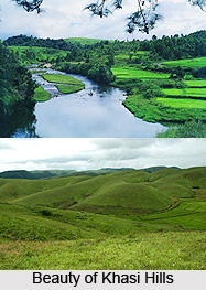
 The Khasi Hills belong to the Garo-Khasi range in the north-eastern state of India, Meghalaya. The hills are located in the central part of Meghalaya and the Garo Khasi range is a part of the Patkai range of the Meghalaya subtropical forests ecoregion.
The region is dominated by the Khasi tribal communities. The area consists mostly of hilly regions which also consist of the Shillong plateau. The highest peak of the region is Lum Shyllong which is 1968 meters high. It is drained by the tributaries of the Brahmaputra and the Surma Rivers.
Khasi Hills are mainly known for housing Sohra, popularly known as Cherrapunjee. Cherrapunjee is recognized for being the wettest place on earth. It is situated a few kilometres south of Shillong town which is considered as one of the most beautiful hill stations in India. The whole Khasi Hills region that forms the central part of Meghalaya is enriched with natural beauty. Every year, nature lovers from various places of the country flock to this hill station to enjoy the natural breeze.
Administration of Khasi Hills
In the yea 1976, the Khasi Hills District was divided into two districts, viz the West Khasi Hills District and the East Khasi Hills District.
West Khasi Hills: West Khasi Hills is presently the largest district of Meghalaya. There are various places in this region that can be visited like Langshiang Falls (third-highest waterfalls in India), Mawthadraishan Peak (second highest peak in Meghalaya), Nongkhnum River Island, Weinia Falls, Thums Falls, Umyiap Paddy Field (longest paddy field in northeast India), Ranikor, Kyllang Rock, Rambrai, Langpih etc.
West Khasi Hills also provide excellent opportunities for trekking, rock climbing, angling and the like. They are home to various peaks that can be scaled. One will also discover bridle paths for trekking and water ways for canoeing and rafting. In addition to these, there are also a number of attractive picnic spots and camping sites.
East Khasi Hills District: In the year 1992, East Khasi Hills District was further divided into two administrative districts of East Khasi Hills District and Ri-Bhoi District. It is mostly hilly with deep gorges and ravines on the southern portion. The most important attraction of the district is the Shillong Plateau which is interspersed with river valley. Shillong peak lying 10-km from the city, offers a stunning view of the scenic countryside. Nohkalikai Falls (one of the tallest falls in India is located near Cherrapunjee), Nohsngithiang Falls, Kynrem Falls, Umiam Lake, and Mawlynnong village are some other places popular among the tourists.


