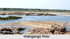
 Wainganga River is a river of India, which originates about 12 km from Mundara village of Seoni district in the southern slopes of the Satpura Range of Madhya Pradesh, and flows to south through Madhya Pradesh and Maharashtra in a very meandering course of roughly 360 miles. It is one of the major tributaries of Godavari River in peninsular India with a catchment area of about 51,000 sqkm and total length of 606 km spread in the state of Maharashtra and Madhya Pradesh. After joining the Wardha River, the united stream was called the "Pranahita", finally empties into the River Godavari at Kaleshwaram, Telangana. The river has urbanized extensive flood plains with sweeping graceful meanders and low alluvial flats and meander terraces. The river has high banks 10 to 15 m on either side. The northern part of the basin is covered by Mahadeo hills and Satpura ranges of the average elevation 625 m above mean sea level. The Wainganga River experiences the tropical climatic conditions with a monthly precipitation of 640 mm in monsoon season.
Tributaries and Distributaries of Wainganga River
Wainganga River receives numerous tributaries on either bank and drains the western, central and eastern regions of the Balaghat district of Madhya Pradesh, Chandrapur, Gadchiroli, Bhandara, Gondia and Nagpur districts of Maharashtra. The major tributaries of the Wainganga river are Thel, Thanwar, Bagh, Chulband, Gadhvi, Khobragarhi, Kathani joining left bank and Hirri, Chandan, Bawanthari, Kanhan and Mul joining the right bank. The Kathani River originates in the Dhanora Pendhri Hills and merges Wainganga near Gadchiroli city. Chandan River is another important tributary of Wainganga of the Balaghat district.
Wainganga River in Literature
Rudyard Kipling used the Wainganga or "Wangunga" in older editions as a major attraction in the Mowgli stories of "The Jungle Book" and "The Second Jungle Book" (1894 - 1895). This river is the primary source of water for all the people of the jungle, the location of the Peace Rock, the place where Shere Khan vows to place Mowgli`s bones once he has killed him, and the final battlefield in "Red Dog". However, the region around the Wainganga is not really a rainforest.


