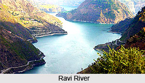
 The Ravi River rises in the majestic Himalayas in the Indian State of Himachal Pradesh and flows north-west past the Chamba River and continuing by turning southwest at the Jammu and Kashmir border. The Ravi River flows in both India and Pakistan and is among the five rivers, which give Punjab its name. It arises in Bara Banghal, a branch of the Dhauladhar Range of Himalayas in the Chamba district of Himachal Pradesh. Flowing southwest and crossing Dalhousie, it cuts another gorge across the Dhauladhar Ranges before entering Punjab near Pathankot and Madhopur.
The river then flows into Pakistan and after running a course of 50 miles enters the Punjab province past Lahore and turning west at Kamalia. Finally, Ravi River empties itself into Chenab River at the southern part of Ahmedpur Sial with a total course of 450 miles (725 km). It is also called `The river of Lahore` since that great city is situated on its eastern bank. On its western bank is located the famous town of Shahdara with the tomb of Jahangir and the Tomb of Noor Jahan.
The Ravi River, a trans-boundary river of India and Pakistan, is an integral part of the Indus River Basin and forms the headwaters of the Indus basin. The waters of the Ravi River drain into the Indian Ocean through the Indus River in Pakistan.
The Ravi"s waters are used for irrigating large areas of land along its course. The Upper Bari Doab Canal, with headwork at Madhopur is at the northern tip of the Indian Punjab state. It irrigates a large area east of the Ravi in India, and its distributaries canal extends into Pakistan. The Lower Bari Doab Canal lies entirely in Pakistan.
Etymology of Ravi River
In Sanskrit literature the town was Iravati. On the right bank of the river there is the beautiful town of Chamba and on its western bank there is the famous tomb of Jahangir. Indians knew the Ravi as Parushani or Iravati in Vedic times and Hydraotes to the Ancient Greeks.
Tributaries of Ravi River: The Ravi River has many tributaries such as;
•Budhil - These tributaries join the Ravi waters about 40 miles downstream from the source. The Budhil River starts off from the Lahual Range and is fed by the glaciers of Manimahesh Kailash Peak and Manimahesh Lake.
•Dhona (Nai) - The Nai on the other hand takes its course from Kali Debi pass and after flowing a length of 30 miles joins the Ravi at Trilokinath.
•Seul River - Seul waters join the Ravi course below Bharmour, the ancient capital of Chamba.
•Saiwa River - Saiwa is another major tributary of the Ravi in Chamba basin joining near Bissoli. At the same place another river that joins Ravi is the Baira Nalla.
•Tant Gari - This is yet another small tributary of Ravi sourced from the Pir Panjal ranges and joining Ravi at east of Bharmour.
Indus Water Treaty of Ravi River
The water of the river is allocated to India under the Indus Water treaty between India and Pakistan. After the partition of India in 1947, the rivers of Ravi along with others in the Indus system was divided between the countries as per the Indus Water Treaty. The two countries had frequent disputes over the water before concluding the Indus Waters Treaty in 1960, which allocated the water of the Ravi to India, in exchange for which Pakistan received exclusive rights to the waters of the Indus and its western tributaries. The Indus Basin Project was subsequently taken up by Pakistan while many inter basis transfers like irrigation; hydropower and several multipurpose projects were built in the Indian Territory.
Water Pollution in Ravi River
In the trans-boundary Ravi River flowing from India to Pakistan, in urban areas of Lahore the pollution levels in the river discharge are reportedly very high, which is attributed to careless disposal of large amount of industrial and agricultural waste water and faulty drainage system in both countries. The river sediments are highly contaminated and have become secondary source for pollution of the river water, even though some control over unauthorized discharges into the river has been checked. The worst affected drainage is the Hudiara drain, a tributary of the Ravi River. It is also a transborder problem involving both India and Pakistan. A UNDP funded a special programme was launched in 2006 to address the issue in both countries.


