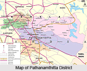
 This Pathanamthitta district is full of pilgrimage centers. Forests cover more than fifty per cent of the total area of this land of temples, rivers, mountain ranges and coconut groves. The district is frequented by visitors from India and abroad often for its water occasions, religious shrines and the cultural training centers. The tourists always find the place interesting because of its variety and diversity. The Western Ghats on the east, Kollam district on the south, Alappuzha district on the west and Kottayam and Idukki districts on the north border Pathanamthitta.
Location:
This is the youngest district in the sate of Kerala. In the border there is Alappuzha district. The district consist of three natural divisions viz the Lowland the Midland and the Highland. The highland stretches through the Western Ghats and descends to midland in the centre, and lastly in down to the lowland. In lowland there is coconut gardens on the western borders of Alappuzha disrict.
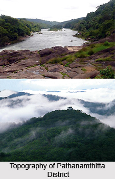
The topography of the district is highly rising and falling. It starts from the tall hill slopes covered with thick forests on the east. Thus along the mountains descends down to the valleys and small hills to the flat land of coconut trees in the west. Pathanamthitta absorbed on the hilly ground of Kerala can rightly be called the headquarters of pilgrimage tourism in the state. Sabarimala, an important Hindu pilgrimage center attracts crores of pilgrims from the different parts of India and the state throughout the whole year.
Climate:
The district has more or less the same climatic conditions as prevailing elsewhere in the state viz, dry season from the Dec to Feb and hot season from March to May. The climate is generally moderate, the temperature rising from 20 C to 39 C. The southwest monsoon from June to September and the North West monsoon from October to November provide quite good rain.
Crops:
Pathanamthitta is a true tropical diversity decorated with fertile agricultural land, plantations and forest. The different crops such as Paddy, tapioca, varieties of vegetables and spices like cardamom, pepper etc. are extensively cultivated in this region. The district also abounds in extensive rubber plantations.
History:
Pathanamthitta is a combination of two words `Pathanam` and `Thitta`, which mean an array of houses on the riverside. This district was formed on 1st November 1982. This has formed in the interest of the hastening process of development. It is presumed that the presently divided regions were formerly under the Pandalam supremacy that had connections with the Pandya Kingdom. Pathanamthitta now includes portions of the former Kollam, Alappuzha and Idukki districts. Some of the important places taken from Kollam district can be mentioned as Pathanamthitta, Adoor, Ranni, Konni and Kozhencherry whereas Thiruvalla and Mallappally are the major places taken from Alappuzha district.
 National Movement:
The district can be proud of its rich contribution to the struggle for freedom. Mahatma Gandhi visited the former Travancore in 1937. At that time he asked his follower Khadar Das T.P. Gopala Pillai to spread the message of Khadi and Charka. Inspired by Gandhiji he founded the `Mahatma Khadi Ashram` at Elanthoor 1941. He also launched a scheme for mobilizing funds for khadi activities known as `ek paise fund` in order to ensure the participation of the whole people in the khadi movement.
There was strong protest in Travancore against the British. In happened in connection with the visit of the Prince of Wales in 1921. In 1922, a student`s strike was held which instilled a lot of spirit and enthusiasm among the freedom fighters. During the same period, Congress leaders like Ponnara Sreedhar and K. Kumar, the participants from Kerala in the flag satyagraha at Nagapur were arrested and also beaten up badly by the police. The contribution of lanthoor K.Kumar, Thadiyal Raghavan Pillai, Pandalam KP and N.G. Chacko to the National Movement have much significance in the history of freedom struggle which should be known to all Indians.
Infrastructure:
There are different hospitals, educational institutions, and different organization in this district. To mention the transportation roadways and railways are important.
Transportation:
The district is connected to the other parts of the country by roadways, railways, and airways.
Roadways:
Roads Division, Pathanamthitta was formed during the month of May 1983. It has happened along with the formation of Pathanamthitta District Formerly the roads of this Division was under the jurisdiction of the B&R Divisions of Kollam and Alappuzha districts. In the Pathanamthitta revenue district the roads division deals with the construction of Roads and maintenance of various PWD roads and bridges. The total length of PWD roads under various categories, such as State High way, Major District roads comes to 1380 Km all-total.
Railways:
Thiruvalla is the only one railway station within the limits of Pathanamthitta District. Thiruvalla station is one of the important stations on the Thiruvananthapuram-Ernakulam broadguage line. The station is situated 30Km away from district head quarters.
Airlines:
The nearest airport is situated at Thiruvananthapuram, which is located at 119 km distance from the Pathanamthitta district.
Administration:
Pathanamthitta district covers two Revenue Divisions, viz. Thiruvalla and Adoor. The district includes 5 Taluks viz., Ranni, Kozhencherry, Adoor, Thiruvalla and Mallappally. There are Sixty Eight Villages in the district under these five taluks. The headquarters of District Panchayat is at Pathanamthitta. There are Nine Blocks viz.,Parakode, Pandalam, Kulanada, Elanthoor, Konni, Mallappally, Ranni, Koipuram and Pulikkeezhu and Fifty Four Grama Panchayats in the district. Adoor, Thiruvalla and Pathanamthitta are under municipalities. The total area of this district is 1475.69 sq. km.
Population:
The number of total population of the district is 1234016. Out of which 589398 are males and 644618 are females. The number of scheduled caste population is 162002 whereas scheduled tribe population is 6549. The literate persons are 1049876 while illiterates are 184140 are in number.


