Home > Travel > Hill Stations in India > Doodhpathri
Doodhpathri
Doodhpathri is a hill station in Badgam District and this place is a hot spot for the tourists for the presence of Greater Himalayan Mountain Range in India.

Share this Article:

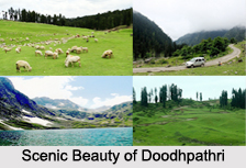
Doodhpathri, Badgam District, Jammu and KashmirDoodhpathri which is known as "Valley of Milk" is a favourite is a tourist destination in Jammu and Kashmir.

Naming of Doodhpathri
The name " Doodhpathri `` means Valley of Milk.

Location of Doodhpathri
Doodhpathri is the hill station in Jammu and Kashmir. It is located in Budgam district of Jammu & Kashmir.

History of Doodhpathri
Doodhpathri is said to be famous for the saint of Kashmir Sheikh ul Aalam Sheikh Noor din Noorani who has prayed here. Once when he was in search of water in the meadows, to offer prayers, he pricked the ground with his stick to search water, and milk came out. He told the milk that it can only be used for drinking and not performing ablution. Hearing this milk at once changed its state to water and meadow got its name Doodhpathri. The water which is at present flowing through the meadows looks like milk from the distance and remains very cold throughout the year. The lush green grasses over the vast meadows and silver shining stream running over the large stones further increase its beauty. Doodhpathri is sloping grassy landscape with a diversity of multi coloured flowers up to Chang. The famous Tosamaidan lies in the west of Doodpathri.

Geography of Doodhpathri
Doodhpathri is situated at an altitude of 8,957 ft from sea level and located at a distance of 42 km from state summer capital Srinagar in Srinagar District of Jammu and Kashmir and 22 km from district headquarter Budgam District of Jammu and Kashmir.

Landform of Doodhpathri
Doodhpathri lies in a bowl shaped valley in the Pir Panjal Range of the Himalayan Mountain Range in India at an altitude of 2,730 m (8,957 ft), above sea level. It is an alpine valley covered with snow clad mountains and the meadows of pine, fir and Deodar. The natural meadows, which are covered with snow in winter, allow the growth of wild flowers such as daisies, forget-me-nots and butter cups during spring and summer.

Demography of Doodhpathri
Doodhpathri has no permanent settlement and is inaccessible during winter due to heavy snowfall. In summer shepherds from the plains of Budgam District bring cattle for grazing and remain at Doodhpathri seasonally for about six months.

Visiting Information
Doodhpathri is easily accessible from Srinagar or Srinagar Airport (SXR), in under 2–3 hours from car or bus. The routes of Doodhpathri are from Srinagar to Budgam, Budgam to Khansahib and Khansahib to Doodhpathri via Raiyar total distance of about 42 km. Another route is from Srinagar Gulmarg road, the route starts from Srinagar to Magam, Magam to Beerwah and Beerwah to Arizal, total distance about 50 km.

Related Articles
Hill Stations of Jammu and Kashmir
Kupwara District, Jammu and Kashmir
Kupwara , Jammu & Kashmir
Budgam District, Jammu and Kashmir
Tourism in Budgam District
Nature Tourism in Budgam District
Districts of Jammu and Kashmir
Tourism in Yusmarg


Share this Article:

Related Articles

More Articles in Hill Stations in India


Shillong
Shillong, the meeting point of tradition and cosmopolitanism, is known as the Scotland of the East.
Tourism in East Khasi Hills District
Tourism in East Khasi Hills District offers a pleasurable experience to the travellers. Magnificent lakes, waterfalls, parks and caves are some of the tourist attractions offered by East Khasi Hills District.
Jaintia Hills District
Jaintia Hills District is an administrative district of Meghalaya and its headquarters are located at Jowai. Economy of Jaintia Hills District is mainly agrarian in character as most of the people are engaged in agriculture.
Ananthagiri Hills
Ananthagiri Hills is an important tourist destination in Telangana. It serves as the pilgrimage tourism site and the leisure tourism site in this state.
Mahendragiri Hill
Mahendragiri is a place of great scenic beauty. The place is surrounded on three sides by hills and thick growth of wild trees.
Tourism in West Garo Hills District
Tourism in West Garo Hills District comprises exploring several beautiful peaks as well as sites of historical importance. Wangala Dance festival of the Garo tribe is another major attraction for the travellers.
Agumbe Hill Station
Agumbe Hill Station in Karnataka is a well-known tourist spot for its sunsets, waterfalls research unit on king cobras.
Hilly and Forest areas
There are four hilly and forest areas in the Indian subcontinent, which are, still the safe haven of the Indian tribes.
Structure on a Hill
Vastu Shastra offers invaluable tips on the construction of a Structure on a Hill.
Yercaud Hill station
Yercaud is a fascinating hill station of Tamil Nadu, situated about 8 kms from Salem.
Wilson Hills
Wilson Hills offers a mesmerizing view of the vast Arabian Sea from a high altitude. The place is immensely enjoyed by the mountaineers and nature lovers.
East Garo Hills District
East Garo Hills District is one of the seven administrative districts of Meghalaya. Williamnagar is the district headquarters. East Garo Hills District is well known in north-east India for its handicrafts and textiles.
Garo Hills
Garo are part of the Garo-Khasi range in Meghalaya. People who reside in the Garo Hills are known as the Garos. The range is part of the Meghalaya subtropical forests eco-region.
Tourism in East Garo Hills District
Tourism in East Garo Hills District includes visits to several historical sites as well as those places that have some association with the culture of the local people. The natural beauty of the region adds charm to the tourism experience.
Khasi Hills
Khasi Hills belong to the Garo-Khasi range located in Himalayas. Khasi Hills are known for housing Sohra, popularly known as Cherrapunjee.
East Khasi Hills District
East Khasi Hills District, an administrative district of Meghalaya, was formed after the bifurcation of Khasi Hills District. Shillong is the district headquarters of East Khasi Hills District.
West Khasi Hills District
West Khasi Hills District is the largest district of Meghalaya with its administrative headquarters located at Nongstoin. West Khasi Hills District was formerly a part of Khasi Hills District and it came into existence in the year 1976.
South Garo Hills District
South Garo Hills District is an administrative district of Meghalaya with its headquarters located at Baghmara. South Garo Hills District is mainly inhabited by Garo Tribes.
Langudi Hill
Langudi Hill, Odisha is a significant Buddhist archaeological site containing ruins of Pushpagiri University, rock-cut caves, Buddhist stupas and numerous other Buddhist relics.
Tendong Hill
Tendong Hill in South Sikkim is located at an altitude of 8530 ft. The hill is deeply revered by the local villagers.
Maenam Hill
Maenam Hill located near to Ravangla town in Sikkim is a famous tourist spot. One can enjoy the breathtaking view of the Kanchenjunga Peak and waterfalls.
Kolli Hills
Kolli Hills is a small mountain range located in Tamil Nadu. It is a part of the Eastern Ghats and serves as a great tourist spot.