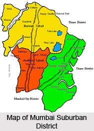
 Mumbai Suburban District of Maharashtra administratively comes under Konkan Division. This district was declared as an independent district on 1st of October, 1990, as a consequence of the bifurcation of the Greater Mumbai into two revenue districts namely, Mumbai City and Mumbai Suburban. Prior to this development, Mumbai Suburban District was a part of Mumbai City District. The jurisdiction of Mumbai Suburban District is from Bandra to Dahisar, from Kurla (Chuna Bhatti) to Mulund and from Kurla up to the Trombay Creek. The headquarters of Mumbai Suburban District is located in Bandra (East). Total geographical area of Mumbai Suburban District is 369 sq kms.
History of Mumbai Suburban District
In the year 1734 Mumbai and its nearby area was under the control of Portuguese. Thereafter Mumbai Island (Bombay Island) was gifted to the Queen of England in the year about 1760-1761. The Vashi creek is situated on the North side and Mahim Causeway is lying on the south side. On the western side, there is Arabian Sea and on the eastern side, the boundary of Thane. This administrative unit forms the limits of Mumbai Suburban District and was part of Goa which was under the control of Portuguese up to 1771 - 1772. Later on, the British rulers took over control of the region of this area. In 1871, Thane District was carved out of the east side of Konkan and Portion of Mumbai Island then known as Taluka South Salesette, Northern Division. In the year 1970, around 50 villages from Taluka Salesette were withdrawn and independent Bandra Mahal was created. In the year 1920, the Salesette Taluka was divided into two parts known as South Salesette Taluka and North Salesette Taluka. Basically Salesette Taluka consisted of 84 villages which were situated from Bandra to Dahisar and Kurla to Mulund. At that time, some villages were withdrawn from Thane district and included in Mumbai Suburban District and South Salesette Taluka was divided into three talukas namely Andheri, Borivali and Kurla. Hectors of land have been reclaimed from shallow creeks and marshy lands.
Administration of Mumbai Suburban District
 The unit `Greater Mumbai` came into existence in April 1950 after merging of Mumbai Suburban and Mumbai City for the purpose of Municipal administration. The Municipal Corporation of Greater Mumbai handles the entire range of civic affairs of the city. For smooth administration the entire city is divided into six administrative zones with 23 wards. The zones are supervised by the Deputy Municipal Commissioners while the administrative head of each ward is controlled by Assistant Commissioner (Ward Officer). There are departmental heads who supervise the work of the major departments pertaining to the civic administration and working under there respective officers. Mumbai Suburban District has three Parliamentary Constituencies along with its 18 Assembly Segments. Mumbai Suburban District is divided into three tehsils namely, Andheri, Borivali and Kurla. Up to the year 1990, the Collector for the District Administration of Mumbai and Mumbai suburban and one Additional Collector were separately posted to look after the administrative work of Mumbai Suburban. On 4th of October 1990, Mumbai Suburban District got separated from Mumbai City. Thereafter, Mumbai Suburban District came into existence with independent district administration. A new Collector was posted as head of the District. Collector is also the District Magistrate of the District. He is responsible for coordinating the activities of various departments under him and acts as the District Coordinator. In the absence of Collector, Resident Deputy Collector functions as the Collector.
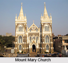
Many important places have adorned the beauty of Mumbai Suburban District like Mount Mary Church, Jogeshwari Caves, Fantasy land, Essel world, Water Kingdom, Sanjay Gandhi National Park, Aarey Colony, Kanheri Caves, Film city, Santacruz Airport, Sahar Airport, Tulsi Lake, Vihar Lake, Powai Lake, Mithi River, Dahisar River, Poiser and Oshiwara River, etc.


