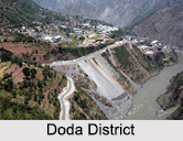
 Doda district is the third largest district of the state of Jammu and Kashmir which is in the middle and outer Himalayan ranges. The total area of this district is 11,691 square kilometres. There are four sub divisions, seven "tehsils" and six towns in this district of Jammu and Kashmir.
History of Doda District
Doda District has a rich history. It is said that one of the ancient Rajas of Kishtwar whose authority extended beyond Doda convinced one utensil maker Deeda, a migrant from Multan (now in Pakistan), to inhabit permanently in this territory and set up an utensil factory there. Deeda is said to have settled in a village which later on was called with his name. With the course of time the name Deeda has changed into Doda, the present name of the town. The entire area of district, including Allaqa Dengbatal (Tehsil Mahore), was in the beginning divided into two independent States of Kishtwar and Bhaderwah.
The Islamic faith entered the region of Doda as a spiritual and moral force, when Hazrat Shah Farid-ud-Din came over to Doda via Dengbattal and Ramban in 1650 A.D. He stayed at Doda for fourteen long years and then left for Kishtwar. Doda acquired the status of a district when it was carved out of the erstwhile district of Udhampur in the year 1948.
Geography of Doda District
Lying in the middle and outer Himalayan ranges of Jammu Region of Jammu and Kashmir State; the district has mostly a hilly terrain. The district is surrounded by district Anantnag of Kashmir Division on its North, district Kishtwar in the North-East, Chamba area of Himachal Pardesh in the South, district, Kathua in the south, district Udhampur in the South-West and district Ramban in the West. The total geographical area of district Doda is approximately 4500 square kilometres. The District is surrounded by snow clad lofty mountains from all sides and mighty Chenab River flows through it. Due to its varying physical features, the district does not have a uniform climate. The climate is temperate in places like Bhaderwah and Gandoh and Sub-tropical in areas like Doda and Thathri.
 Demography of Doda District
According to the 2011 census, Doda district has a population of 409,576. The district has a population density of 79 inhabitants per square kilometre. It has a sex ratio of 922 females for every 1000 males and a literacy rate of 65.97%. The district is Kashmiri speaking with Muslim majority. There are three folk languages Sirazi, Gojari and Bhadrawahi, a Dogri-Kangri language spoken by about 53,000 people in Doda district and written in both the Arabic and Devanagari scripts.
Administration of Doda District
Doda district has 406 villages of which three are un- inhabited. The District has been divided in two Sub Divisions Doda and Bhadarwah. It has four Tehsils Doda, Bhadarwah, Thathri, and Gandoh. The head of District Administration is Deputy Commissioner. He also acts as the collector in case of Revenue matters, as District Development Commissioner in case of District Developmental works, as District Magistrate in case of maintenance of Law and Order and General Administration, and as District Election Officer in case of conducting Elections. The Deputy Commissioner is aided by a number of Officers like Additional Deputy Commissioner, Assistant Commissioner (Revenue) and Sub Divisional Magistrate. Doda District has two assembly constituencies: Bhaderwah and Doda.
 Culture of Doda District
Doda District is known, not only for its prosperous cultural legacy and ethical values but also admired for its age-old traditions of secularism and the spirit of tolerance, which have been since times immemorial, binding the people together. The District has a mixed culture and the people are Pahari Speaking. Because of its connectivity with Jammu, Srinagar, Himachal Pradesh and Ladakh, people usually speak Kashmiri, Ladakhi, Dogri and some Pahari languages like Bhadarwahi, Kishtwari and Serazi.
Tourism in Doda District
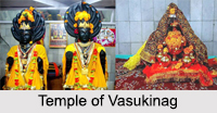
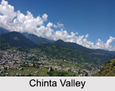
Doda district is noted for several places of pilgrimage tourism. Kailash Yatra is a well-known pilgrimage of the area which is regarded an important Hindu pilgrimage. The other two pilgrimages revolve around historically significant and religiously noteworthy temple of Gupt Ganga and Vasukinag. Reushra is a majestic peak having a height of 11,000 feet. On one side is situated the sleepy valley of Jai and humming valley of Chinta while on other side is the hitherto unexplored region of Chiralla. Reushira peak is beset with ancient temple of Goddess Durga. Thousands of devotees visit the temple to offer prayers, especially during Navaratris. There are numerous trekking places which are a major attraction among the adventure tourists. Chinta Valley, is a picturesque valley located at a height of 6,500 feet. It has thick coniferous forest on all sides and Chinta River flowing through it. Many scenic spots are situated around this place.
Visiting Information of Doda District
There are two National Highways connecting the District. These National Highways are NH-1A and NH-1 B. The general approach to the whole of the District is through road transport Taxi, Deluxe Buses etc. Road transport services are with no trouble available to reach District Head Quarter Doda and to other Tourist Spots of District Doda. Visitors coming from other parts of the country can also utilise the Flight or Train services up to Jammu or Srinagar.


