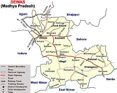
 Dewas District an administrative district of Madhya Pradesh, came into being in the year 1948. Dewas town is the district headquarters. This district lies between 20 degree 17 minutes and 23 degree 20 minutes north latitude and 75 degree 54 minutes and 77 degree 8 minutes east longitude.
Dewas District is now divided in to six tehsils namely Sonkatch, Dewas, Bagli, Kannod, Tonk-Khurd and Khategaon. Dewas tehsil is situated on the northwestern part of the district, Sonkatch on the northeastern part, Bagli on the south, Kannod on the south-central part and Khategaon on the Southeast. Proper roadways connect all the tehsil head quarters. The head-quarters of Dewas tehsil, which is also the district headquarters, is situated on the Mumbai-Agra National Highway No 3 and is also connected by broad-gauge railway line of western Railway.
History of Dewas District
Dewas District gets its name from the district headquarters town, Dewas which is said to have been derived on the basis of two traditions. One is that Dewas lies on the foot of a conical hill, known as Chamunda hill. It is about 300 feet high above the ground level. On top of the Chamunda Hill lies the shrine of Chamunda. The image of Chamunda is cut in rocky wall of a cave. It is, therefore, known as Devi Vashini or the Goddess`s residence. From this the name Dewas (dev-vas) seems to have been derived. The other view of the probable origin is from the name of the founder of the village Dewasa Bania.
Geography of Dewas District
Geography of Dewas District mainly includes four physiographic regions namely Dewas plateau, Vindhya Mountain Range, Kali Sindh River Basin, and Middle Narmada River valley. All these regions have different geographic features. Narmada River, Kali Sindh River and Shipra River are the main rivers that are flowing through Dewas District. Dewas District is bounded by Ujjain District in the north, Indore district in the west, West-Nimar District in the south-west, East Nimar District in the south, Hoshangabad District in the South East, Sehore district in the east and Shajapur district in the north-east. The Tropic of Cancer passes through Dewas District near Nemawar village south of Khategaon town. Dewas District is also rich with diverse species of medicinal herbs and significant plants.
Demography of Dewas District
According to the population Census in 2011, Dewas District had population of 1,563,107 of which male and female were 805,212 and 757,895 respectively. The population of Dewas District constituted 2.15 percent of total population of Madhya Pradesh. The population density of Dewas district is 223 people per sq. km. Dewas district is now administering 7,020 square kilometres of areas. The average literacy rate of Dewas District was 70.53 percent. If things are looked out at gender wise, male and female literacy rates were 82.14 and 58.27 percent respectively. The total literates in Dewas District were 944,968. The male and female were 565,242 and 379,726 respectively.
Education in Dewas District
Dewas District has many well-known primary schools and the higher secondary schools. These schools are providing the proper education to all the students. For higher education, there are a few colleges. Some of the well liked schools and colleges are The Pioneer Public School, Govt Girls Degree College, Govt. K.P. College that is affiliated to Vikram University, HAHU Medical College, Prestige Institute of Management, Maulana Azad Collage of Professional Studies (MACPS), Guru Vashishta College, Govt. Polytechnic College, New Tech Institute of Engineering and Technology and Synergy Institute of Technology and Science.
Economy of Dewas District
In the recent years, modern industry has taken off in Dewas District in a big way. The growth in industry sector has given jobs to local factories. At the same time, traditional crafts such as shoes, synthetic Indian carpets, leather works (bags, belts, women purses, coats, briefcases etc.) have significance in the economy of Dewas District. Agriculture is also one of the main sources of economy. Many heavy industries have been setup for oil extraction from Soyabean. To control the Indian economy, Bank Note Press or the Government Mint, a Central Government Organization for printing of Indian Currency is also situated here.
Culture of Dewas District
Folk songs and folk dances are the major cultural activities of Dewas District. Most important cultural activity of the district is `Malvi song`. Folk songs are also very popular on marriages, festivals and local village fairs. Several festivals are celebrated in the district with huge enthusiasm. Garba Dance is also very popular in the district. Dewas is also a very important centre of classical music.
Tourism in Dewas District
There are several renowned exploring sites in Dewas District. Kavadia Hills, Pawar Chattries, Gidiya Khoh, Chamunda Tekri, Mahakaleshwar Bilawali, Siddheshwar Mahadev Temple, Kela Devi Temple, Mahadev Temple, Shri Manibhadra Veer Temple, Grace Church, Datta Mandir, Kassabban Masjid, Kali Masjid and Shahi Jama Masjid are some of the well-liked attractions of Dewas District. All these places are worth visiting and attract people from everywhere.
The nearest airport is situated at Indore at about 40 kilometres away from Dewas and several domestic airlines connect this city with other major cities of the country. Moreover, Dewas is well connected by good train services to Delhi, Mumbai, Kolkata, Chennai, Jaipur and all other major cites. Dewas is situated on National Highway Number 3. The town of Dewas is centrally located having links to adjoining Ujjain District, Sehore District, Bhopal and Indore District. The city is well connected by roadways. It is situated at a distance of 560 kms from Agra, 160 kms from Bhopal, 33 kms from Ujjain and 35 kilometres from Indore by road.


