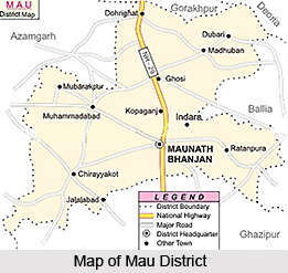
 Mau District is one of the administrative districts of Uttar Pradesh is situated in its south-eastern part. It has its headquarters located at Mau town. This district is located at 83 degree 17 minutes to 84 degree 52 minutes east longitude and 25 degree 47 minutes to 26 degree 17 minutes north latitude. Mau District occupies a total area of 1,71,459 hectares. Mau District is bounded in the south by Ghazipur District, in the east by Ballia district and in the west by Azamgarh District. The northern boundary of the district is bounded by Ghaghara River.
History of Mau District
Many myths are popular regarding history of Mau District. In common opinion Mau is considered as a Turkish word, which means `Garh`, `Padav`, `Chavani`. No historical records are available regarding early habitants of Mau. Some historical accounts suggest that Akbar passed through Mau, on his way towards Allahabad. During his reign Sher Shah Suri visited Kolhuvavan (Madhuban) to meet sufi saint Syed Ahmad Wadva. Various developmental works were undertaken by Sher Shah during his reign towards economic development of Mau region. Further, as per history of Mau District, during the period of freedom struggle of the country, residents of Mau had given their full support to the movement. Mahatma Gandhi came here in Dohrighat on 3rd of October, 1939. In salt law breaking movement and during 1942, Quit India Movement Mau District had actively taken part. Mau was an important township of Azamgarh District before its creation. On 19th of November, 1988 it was made a district, largely due to the effort of Late Kalpnath Rai, who was a Member of Parliament from Ghosi Parliamentary seat.
Mau District is basically agriculture based district. However, the main industrial setup here is of cloth making by power loom due to presence of a large number of weavers in the district.


