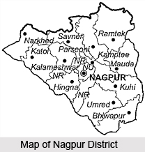
 Nagpur district, located at the very centre of the Indian state, lies in the state of Maharashtra. Nagpur was the capital of the Central Provinces and Berar State till 1960. On 1st May 1960, it became the Second Capital of Maharashtra State. Located here is Nagpur city, popularly known, as the `Orange Capital of India`. The district covers a total area of 9890 Sq. kms. It contains of 13 Tahsil places and 1969 small villages. According to the 2001 census, the population of this region is 34, 36,765. The history of the district can be traced right back to the 1st Century AD, following which, the growth and development of the district is strongly connected to the rise and fall of the city of Nagpur. Further details about the district of Nagpur are given below.
Location of Nagpur District
Nagpur district lies between the north latitude of 21.07 and east longitude of 79.07. It is located at the very geographical centre of India. In fact the zero milestone of India is in the city of Nagpur. All major highways NH-7 (Varanasi - Kanyakumari) and NH-6 (Mumbai - Sambalpur - Kolkata) and major railways trunk route (Mumbai, Chennai, Howrah, Delhi) pass through the city.
History of Nagpur District
History of Nagpur District is closely connected to the history of the city of Nagpur. Its earliest history can be traced back to the 1st century AD. Evidences found herein suggest that it was once part of the Vakataka dynasty, Maurya empire and Shunga empire. The name of Nagpur appeared for the first time on record in the 10th century A.D. The Gond kings occupied the district for quite a bit of time till it came under the sway of the Bhosles. It was finally lost by the Marathas to the British in the year 1853, following which Nagpur was pushed into the throes of the freedom struggle. Finally, in the year 1960 A.D., Nagpur city and district were transferred to Maharashtra State, as a part of state reorganization. Since the first session of the state legislature was organized at Nagpur, the city was assigned the status of the second capital to Maharashtra.
Geography of Nagpur District
Nagpur town is dominated by the British fort built in 1818 on the twin hills of Sitabuldi in the centre of the city of Nagpur. The surrounding region is an undulating plateau rising northward to the Satpura mountain Range, from 889 to 2,142 feet (271 to 653 m) high. It is drained by the Kanhan River and Pench River in the centre, the Wardha River in the west, and the Wainganga River in the east. Both these rivers later merge as tributaries into the Godavari River. The soil is fertile black (cotton) in the west and the north and alluvial in the east. The climate of Nagpur follows a typical seasonal monsoon weather pattern. The peak temperatures are usually reached in May or June and can be as high as 48 degree Celsius. The onset of monsoon is usually from July and the season extends up to September, with monsoon peaking during July and August.


