 Nalgonda district is located towards the southern part of Telangana, a newly formed state in India with the capital Hyderabad for 10 years. Previously the district was known by the name Nilagiri, the meaning of which is `blue hill`. Later on the district was named after Ala-ud-Din Bahman Shah after he had conquered the region. Other famous dynasties which had reigned over the district were the Satavahana Kings, the Kakatiyas and the Mughal Rulers.
Nalgonda district has been divided into 59 mandals under 4 Revenue Divisions. As far as the history of the district is concerned it dates back to the Paleolithic Age. Gradually with passing time Nalgonda has moved towards advancement and development. As such Nalgonda has been influenced by a number of rulers and the district has strongly survived the ravages of time and human vandalism and till today has retained its pristine glory. The district of Nalgonda became a part of Telangana on 1st November 1956.
 Geography of Nalgonda District
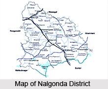
Nalgonda district lies between 6-25 degree and 17-50 degree north latitudes and vertically it is within 78-40` and 80-05` east longitudes. It encompasses an area of 14240 square kilometers which is equal to 5.18 percent of the total land area of Telangana. Towards the north of Nalgonda lie Medak district and Warangal district. Towards the south are Guntur district and Mahbubnagar district, the Khammam district and the Krishna district lies on the east of Nalgonda and last but not the least Rangareddy is placed towards the west of Nalgonda. The major rivers of the area are Krishna river, Musi river, Aler river, Dindi river, Hallia river, Kongal river and Peddavagu river. The climate of Nalgonda district is hot and dry with the month of May being the hottest month of the year. On the other hand December is the coldest month of the year. Maximum rainfall in the region is received from the south-west monsoon winds and a lot of rain takes place during the month of September.
Population of Nalgonda District
According to the census of 2001, the district has a population of 3,238,449. The density of population in the district is equal to 242 persons per square kilometre and the literacy rate in the region is 58 percent. As far as vegetation is concerned around 7 percent of the land in Nalgonda is covered by forests. The types of forests which are commonly found in the region are mixed deciduous forest and tropical thorn forests.
 Culture of Nalgonda District
The religions which are mainly practiced by the people of Nalgonda District are Hinduism, Islam and Christianity. It is true that three different religions exist in the district yet the people live with each other in harmony. They greet each other on each others` festivals. The main festivals which are celebrated in the region with pomp and show are Ugadi, Dussehera, Diwali and Sankranti. The other festivals are Id-ul-fitr and Christmas. Besides the religious festivals the other modes of entertainment which are practiced by the people are watching of various mythological dramas. Rural dances like Kolatam and urban dances including Bharatnatyam and Kuchipudi are an integral part of Nalgonda district. The Carnatic and Hindustani Music are also associated with the lives of the people.
Education in Nalgonda District
The district authorities of Nalgonda district have set aside a number of goals and objectives in order to improve the state of education in the district. In order to realise their aims and objectives the authorities have taken several steps. They have started a number of primary schools in the district so that every child gets the opportunity of admission into schools. They have also upgraded the existing primary schools to upper primary schools. In the field of education they have initiated a number of audio-visual modes of learning and at the same time have also begun several vocational courses. Thus it can be well understood that the district of Nalgonda is gradually improving in the field of education.
Economy in Nalgoda District
As far as economy is concerned most of the people in Nalgonda district are engaged in agriculture and hence it is obvious that most of the revenue earned in the region is from agriculture.
Tourism in Nalgonda District
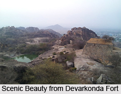
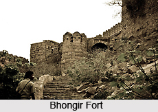
The district of Nalgonda has no dearth of tourist destinations. The temples of Nalgonda district are famous for its architectural beauty. In fact the temples which gloriously stand in the district today, testifies the royal glory of the Satavahana and the Kakatiya rulers. Some of the well known temples of the district are Pachala Someswara Temple, Agastheswara Temple, Chayala Someshwara Temple and Kulpakji Teerth. These temples have wonderful architectural designs and styles. The other important tourist destinations of the region are Bhongir Fort, Nandikonda, Kolanupaka, Devarkonda Fort, Gajulabanda Yeleswaram and the District Archaeological Museum has several stone and bronze sculptures, ancient paintings and some epigraphic objects.


