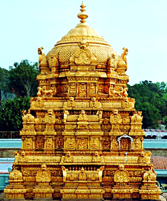
 Chittoor is an important district located in the southern part of Andhra Pradesh and is a part of Rayalseema. The district has further been divided into 31 mandalas. The district of Chittoor is well known for the Tirupati Temple.
History of Chittoor
The history of Chittoor district has been shaped by several Dravidian rulers. The early settlers of the district were the Kurumbas. After Kurumbas the Ballal dynasty had taken the reigns of the Chittoor district in hand. Then it was the Vijaynagara dynasty that rose to prominence and had started controlling the Chittoor district. It can be said that Chittoor was primarily occupied by the Dravidians and had witnessed the reigns of several dynasties. The Chittoor district was formed on 1st April 1911. The district was formed on the recommendation of the Pataskar Commission after dividing the districts of Cuddapah, Nellore and North Arcot.
Geography of Chittoor
Chittoor district is located towards the southern part of Andhra Pradesh along the banks of River Ponnai. It encompasses an area of 15,359 square kilometers. It lies between 12.37 degrees and 14.8 degrees north latitude and the longitudinal expanse of the district is between 78.3 and 79.55 degrees east longitude. Towards the north of Chittoor is the Cuddapah district, Anantpur lies to the north-west of Chittor and Nellore lies to the north-east of the district. In the south Chittoor is bounded by the districts of Vellore and Thiruvallur of Tamil Nadu and in the west the district is bounded by the Kolar district of Karntaka. Around 30 percent of the land area in Chittoor is covered by forests. The type of soil that is generally found in the district of Chittoor are red-loamy, red sandy, black clay, black loamy, black sandy and red sandy. Mango and tamarind are important tress in the district of Chittoor. Some of the important rivers of the Chittoor district are Ponnai, Swarnamukhi, Kusasthali, Bahuda, Kalyani, Pedderu, Beema, Pincha and Araniyar. Cattle rearing are an important occupation in Chittoor.
As far as the temperature of the district is concerned it is seen that temperatures in the western and the eastern part of the district vary. The temperature in the western part is lower compared to the temperature in the eastern part of the district. During the summer season the temperature in the western part rises as high as 46 degree centigrade and in the eastern part the temperature ranges around 36º to 38°C. Whereas in the winter months the temperature of the western part of the district is 12 to 14 degrees centigrade and temperature in the eastern part is around 16 to 18 degree centigrade.
 Chittoor receives an annul rainfall of 918.1 mm from the South-Western and the North-Eastern Monsoon. As a result the rainfall in the district is spread across the months of June to September and October to December.
The flora of Chittoor comprises dry South Indian deciduous mixed forests, southern cutch thorn forests and tropical evergreen dry forests. The fauna of the district is also widely varied. It includes tigers, panthers, wild pigs, porcupines, hyaenas, wolves, jackals and a lot more. A large variety of birds are also found in the district of Chittoor like the large grey shrikes, mynas, vultures, eagles, kites, owls, partridges, green pigeons, peacocks and many more add to the variety of the avian culture of Chittoor.
Demography of Chittoor
According to the census of 2001 the population of the Chittoor district is 3,745,875. The density of population in the district is 246 persons per square kilometer. Out of this population around 21.65 percent of the population is urban. The most commonly used language in the district is Telegu and other languages used are Tamil, English and Hindi language. The literacy rate in Chittoor is 66.77 percent. Among the literate population 77.62 percent of the male population is literate while 55.78 percent women are literate. The work force of the district comprises 46.85 percent of the entire population.
Tourism in Chittoor
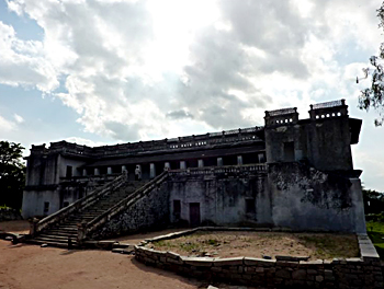
Tourism in the Chittoor district has mainly flourished due to some of the ancient and modern temples that are housed in the heart of the district. Some of the important and well known temples in the district of Chittoor are Tirumala, Kanipakam and the Sri Kalahasti Temple. The Tirupati Temple in the district of Chittoor is the richest temple in India and receives around 200,000 visitors a day. In combination with the Vellore district, the Chittoor district in the southern part of Andhra Pradesh forms an important tourism cluster in the city. Apart from the temples the district is also famous for the several archaeological findings which are found in the district. Gurramkonda in the western part of the district is a well known historic centre which includes an old fort and a sultan"s palace known by the name Rangini Mahal. The Horsley Hills in the Chittoor district is an important summer resort and attracts lot of visitors to the district. Some of the other notable places of tourist attraction in Chittoor are Ardhagiri and Chandragiri.
Economy of Chittoor
The economy of Chittoor is mainly agro based. It has a huge market for mango, sugarcane, grain and peanuts. The important industries of the district include oilseeds, rice milling, Nutrine Confectionaries, a well known chocolate industry, mango pulp manufacturers.
The granite industry is also of prime importance in the district of Chittoor. The Tirupati Temple in Chittoor is also a major source of earning for the district. This is because a large number of devotees throng the temple throughout the year.


