 Koraput District, an administrative district of Orissa, was created on 1st.April, 1936. It has its headquarters at Koraput. In the backdrop of green valleys contemplating immaculate freshness, Koraput District is the hub of the tribal population in Orissa. Bounty of meadows, forests, waterfalls, terraced valleys and darting springs dotted over the district makes it alluring to the nature loving people. Only with a small geographical area of about 8379 sq kms, Koraput district is one of the historical districts of the state of Orissa.
Location of Koraput District
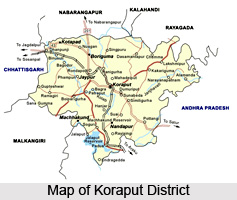
Koraput District is located between 17 degree 40 minutes 20 degree 7 minutes north latitude and between 81 degree 24 minutes 84 degrees 2 minutes east longitude. Average altitude of the district is 2900 feet above the sea level. Total geographical area of the district is 8379 sq kms. Koraput District is bounded by Rayagada District and Srikakulam District of Andhra Pradesh in the east. It is surrounded by Bastar District of Chhattisgarh in the west, by Nowarangpur District, Vizianagaram District and Visakhapatnam District of Andhra Pradesh in the south.
History of Koraput District
Regarding the historical facts of Koraput, not much is known. Since, the past records of the Koraput district are limited to the excavated facts and the mere assumptions of the historians, a codified historical document of the Koraput district does not exist. As far as the history of Koraput is concerned, the region of Koraput existed far back in the 3rd century BC when it belonged to the valiant and dreaded Atavika people. The vigorous Atavika, the original inhabitants of the Koraput fought hard to retain their kingdom and glory but unfortunately subdued by the Mauryas in the Kalinga warfare. As the chronicle of Koraput runs, Koraput was under the Mauryas for a consid erable period of time. The region successively came to be ruled by several dynasties, like Satavahans, Ikshvakus, Nalas, Ganga kings and kings of Suryavanshi, who dominated the Koraput region before the arrival of the British. It was the British, who composed the separate district of Koraput in the year of 1936 and in the post independence period it was adjoined with the Orissa province of Indian Union. Koraput abounds in the imprints of Orissa`s glorious past.

Culture of Koraput District
Handicrafts of Koraput District reflect the vivid imagination and skillful creativity of the indigenous people. The exquisite, vegetable-dyed scarves and saris spun by `Mirgan` weavers are Koraput`s signature handicrafts, nationally awarded and internationally renowned for their breathtaking beauty and rare artistry. Besides these, there are other handicrafts ranging from terracotta to metal work. Likewise Koraput Region is also rich with traditional art, craft, like paper making, mask making, lacquer art, bamboo crafts, docra casting, terracotta, metal works, weaving, leaf art, paddy craft etc. Every aspect of tribal life is charming and colourful. But the place of honour is occupied by tribal dance and music. The invigorating dances set to the beat of tapping music of traditional instruments are a way of life for the tribal communities. In all seasons and occasions, the people sing and dance in Koraput.
Tourism in Koraput District
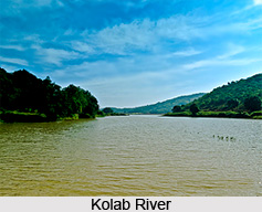
Koraput District offers several sightseeing options. Koraput has several places of the interest that attract people from far and wide. There is a Tribal Museum in the district headquarters caters to and educates the tourists about the culture and heritage of the tribal communities. The majestic waterfall, also known as `Matsya Tirtha` falls from a height of 175 meters. A hydroelectric project with its winch developed amidst deep greenery is a place for pleasure. Important cave shrine of Lord Shiva situated on a lime stone hill on the bank of Kolab River, surrounded by natural scenery.
Temples, monasteries and other historical monuments from the medieval period with great historical significance stand as footprints to tell the story of the rich history of Koraput District.


